Karten und Pläne
Strecke (Nebenbahn) Bitterfeld - Stumsdorf. Höhenplan und Lageplan von km II + 850 bis km IV + 850. Ausführliche Vorarbeiten der Variante I. Blatt 3./I
Enthält u.a.: Verlauf in den Gemarkungen Bitterfeld, Sandersdorf und Greppin.
- Reference number
-
G 12. Pläne, IV/2834 (Benutzungsort: Dessau)
- Former reference number
-
Registratursignatur: Reichsbahndirektion. Halle: Schrank 4, Fach 24, Stück Iul, Buchungs-Nr. 27
- Further information
-
Farbe: teilkoloriert
Maßstab: 1:2.500 und 1:250
Beschreibstoff: Pappe
- Context
-
Deutsche Reichsbahn. Reichsbahndirektion Halle >> 11. Pläne >> 11.03. Bahnstrecken (nach Streckennummern) >> 11.03. Bitterfeld - Zörbig - Stumsdorf
- Holding
-
G 12 (Benutzungsort: Dessau) Deutsche Reichsbahn. Reichsbahndirektion Halle
- Date of creation
-
1895 - 1896
- Other object pages
- Provenance
-
Reichbahndirektion Halle
- Former provenance
-
Königliche Eisenbahndirektion Halle
- Last update
-
17.04.2025, 3:25 PM CEST
Data provider
This object is provided by:
Landesarchiv Sachsen-Anhalt. If you have any questions about the object, please contact the data provider.
Landesarchiv Sachsen-Anhalt. If you have any questions about the object, please contact the data provider.
Object type
- Karten und Pläne
Time of origin
- 1895 - 1896
Other Objects (12)

Strecke (Nebenbahn) Bitterfeld - Stumsdorf. Lageplan von km 0 bis km II + 850. Blatt 1./I
Strecke (Nebenbahn) Bitterfeld - Stumsdorf. Höhenplan von km 0 bis km II + 850. Ausführliche Vorarbeiten der Variante I. Gemarkung Bitterfeld. Blatt 2./I
Strecke (Nebenbahn) Bitterfeld - Stumsdorf. Höhenplan und Lageplan von km IV + 850 bis VI + 655,62. Ausführliche Vorarbeiten der Variante I. Blatt 4./I
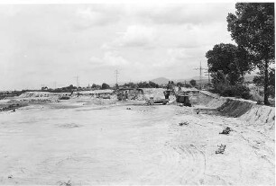
Erdbau bei km 650,850
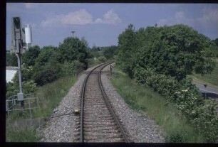
Strecke in km 25+850
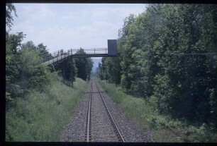
Strecke in km 45+850
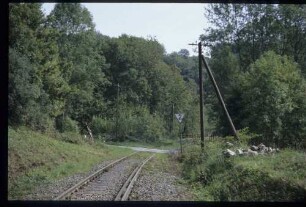
Strecke in km 14+850
Strecke (Nebenbahn) Bitterfeld - Stumsdorf. Höhenplan und Lageplan von km X + 700 bis km XII + 600. Ausführliche Vorarbeiten. Blatt 7
Strecke (Nebenbahn) Bitterfeld - Stumsdorf. Höhenplan und Lageplan von km VIII + 750 bis km X + 700. Ausführliche Vorarbeiten. Blatt 6
Hochwasserprofile von km 79,000 bis km 81 + 850
Strecke (Nebenbahn) Bitterfeld - Stumsdorf. Höhenplan und Lageplan von km VII + 750 bis km IX + 945. Ausführliche Vorarbeiten. Blatt 5/a
Strecke (Nebenbahn) Bitterfeld - Stumsdorf. Höhenplan und Lageplan von km V + 580 bis km VII + 750. Ausführliche Vorarbeiten. Blatt 4/a
Strecke (Nebenbahn) Bitterfeld - Stumsdorf. Lageplan von km 0 bis km II + 850. Blatt 1./I
Strecke (Nebenbahn) Bitterfeld - Stumsdorf. Höhenplan von km 0 bis km II + 850. Ausführliche Vorarbeiten der Variante I. Gemarkung Bitterfeld. Blatt 2./I
Strecke (Nebenbahn) Bitterfeld - Stumsdorf. Höhenplan und Lageplan von km IV + 850 bis VI + 655,62. Ausführliche Vorarbeiten der Variante I. Blatt 4./I
Erdbau bei km 650,850
Strecke in km 25+850
Strecke in km 45+850
Strecke in km 14+850
Strecke (Nebenbahn) Bitterfeld - Stumsdorf. Höhenplan und Lageplan von km X + 700 bis km XII + 600. Ausführliche Vorarbeiten. Blatt 7
Strecke (Nebenbahn) Bitterfeld - Stumsdorf. Höhenplan und Lageplan von km VIII + 750 bis km X + 700. Ausführliche Vorarbeiten. Blatt 6
Hochwasserprofile von km 79,000 bis km 81 + 850
Strecke (Nebenbahn) Bitterfeld - Stumsdorf. Höhenplan und Lageplan von km VII + 750 bis km IX + 945. Ausführliche Vorarbeiten. Blatt 5/a