Karten und Pläne
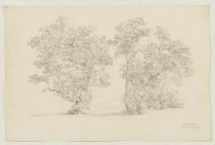
Ammer, Köstlinstr./Goldersbachmündung 1:500 Lageplan+Lage der Bäume
- Reference number
-
A 616/210
- Further information
-
Maßstab: 1:500
- Context
-
A 616 Pläne zur Landschaftsplanung
- Holding
-
A 616 Pläne zur Landschaftsplanung
- Other object pages
- Last update
-
29.04.2025, 8:35 AM CEST
Data provider
This object is provided by:
Stadtarchiv Tübingen. If you have any questions about the object, please contact the data provider.
Stadtarchiv Tübingen. If you have any questions about the object, please contact the data provider.
Object type
- Karte und Plan
Other Objects (12)

Ammer, östl. Köstlinstr. 1:500, Lageplan
Bäume an der Ammer
Sep. Ammern Ammern
Ammer, Kurt. Ammer, Karin

Ammern

Ammern

Ammern
⟦Ammern⟧
Ammer
Ammer
Ammern
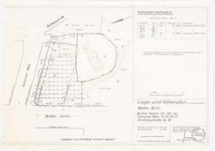
Gemeindehaus Berlin-Britz: Lage-/ Höhenplan 1:500
Ammer, östl. Köstlinstr. 1:500, Lageplan
Bäume an der Ammer
Sep. Ammern Ammern
Ammer, Kurt. Ammer, Karin
Ammern
Ammern
Ammern
⟦Ammern⟧
Ammer
Ammer
Ammern
Gemeindehaus Berlin-Britz: Lage-/ Höhenplan 1:500
Ammer, östl. Köstlinstr. 1:500, Lageplan
Bäume an der Ammer
Sep. Ammern Ammern
Ammer, Kurt. Ammer, Karin
Ammern
Ammern
Ammern
⟦Ammern⟧
Ammer
Ammer
Ammern