- Reference number
-
Slg. 17, III/5 (Benutzungsort: Dessau)
- Former reference number
-
Akz. 14/97
- Dimensions
-
Höhe (cm): 67.3; Breite (cm): 58
- Context
-
Karten Anhalts >> I. Karten des Fürsten- bzw. Herzogtums Anhalt und angrenzender kursächsischer Gebiete
- Holding
-
Slg. 17 (Benutzungsort: Dessau) Karten Anhalts
- Date of creation
-
1752
- Other object pages
- Last update
-
17.04.2025, 3:20 PM CEST
Data provider
This object is provided by:
Landesarchiv Sachsen-Anhalt. If you have any questions about the object, please contact the data provider.
Landesarchiv Sachsen-Anhalt. If you have any questions about the object, please contact the data provider.
Object type
- Karten und Pläne
Time of origin
- 1752
Other Objects (12)

Mappa Geographica exhibens Ducatum Saxoniae (Teil 3)
Mappa Geographica exhibens Ducatum Saxoniae (Teil 2)
Mappa Geographica exhibens Ducatum Saxoniae (Teil 1)
Mappa geographica exhibens principatum Brandenburgico Onolsbacensem

Mappa geographica ... exhibens circulos aliquot Germaniae
Mappa geographica exhibens Principatum Brandenburgico-Onolsbacensem
Mappa geographica exhibens Principatum Brandenburgico Onolsbacensem
Mappa geographica circuli Metalliferi Electoratus Saxoniae
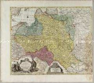
Mappa Geographica, ex novissimis observationibus repraesentans Regnum Poloniae Et Magnum Ducatum Lithuaniae

Nova et exacta mappa geographica exhibens circulum Westphalicum

Nova Et Exacta Mappa Geographica exhibens Circulum Westphalicum
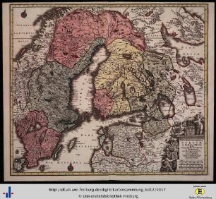
Nova mappa geographica Sueciae ac Gothiae Regna ut et Finlandiae Ducatum ac Lapponiam.
Mappa Geographica exhibens Ducatum Saxoniae (Teil 3)
Mappa Geographica exhibens Ducatum Saxoniae (Teil 2)
Mappa Geographica exhibens Ducatum Saxoniae (Teil 1)
Mappa geographica exhibens principatum Brandenburgico Onolsbacensem
Mappa geographica ... exhibens circulos aliquot Germaniae
Mappa geographica exhibens Principatum Brandenburgico-Onolsbacensem
Mappa geographica exhibens Principatum Brandenburgico Onolsbacensem
Mappa geographica circuli Metalliferi Electoratus Saxoniae
Mappa Geographica, ex novissimis observationibus repraesentans Regnum Poloniae Et Magnum Ducatum Lithuaniae
Nova et exacta mappa geographica exhibens circulum Westphalicum
Nova Et Exacta Mappa Geographica exhibens Circulum Westphalicum