- Reference number
-
StAM, Plansammlung 7142
- Former reference number
-
W 6204
- Dimensions
-
26 x 46 cm
- Formal description
-
Transparentpapier; 1 : 100
- Language of the material
-
deutsch
- Context
-
Plansammlung >> Plansammlung >> 2. Plansammlung ab Nr. 4192 (nach Provenienzen) >> 2.1. Innere Verwaltung >> 2.1.6. Wasserwirtschaftsämter >> 2.1.6.1. Wasserwirtschaftsamt Weilheim
- Holding
-
StAM, Plansammlung Plansammlung
- Date of creation
-
1947
- Other object pages
- Provenance
-
Wasserwirtschaftsamt Weilheim
- Last update
-
22.04.2025, 1:57 PM CEST
Data provider
This object is provided by:
Staatsarchiv München. If you have any questions about the object, please contact the data provider.
Staatsarchiv München. If you have any questions about the object, please contact the data provider.
Object type
- Karten und Pläne
Time of origin
- 1947
Other Objects (12)

Loisachregulierung - Regelquerschnitt von km 41,786 - 45,098
Regelquerschnitt
Loisachregulierung - Boschhofbrücke bei km 21,155
Loisachregulierung - Boschhofbrücke bei km 21,155
Loisachregulierung - Maxkroner Steg, bei km 28.214
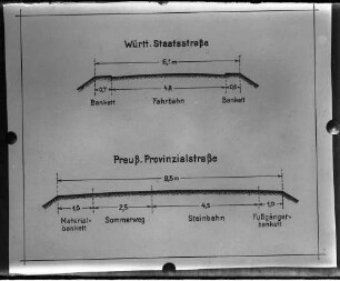
Regelquerschnitt Straßenbau
Regelquerschnitt Straßenbau
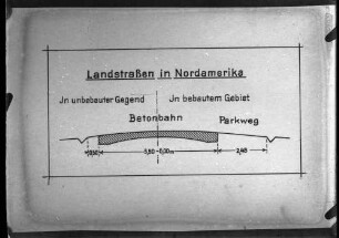
Regelquerschnitt Straßenbau

Regelquerschnitt Straßenbau
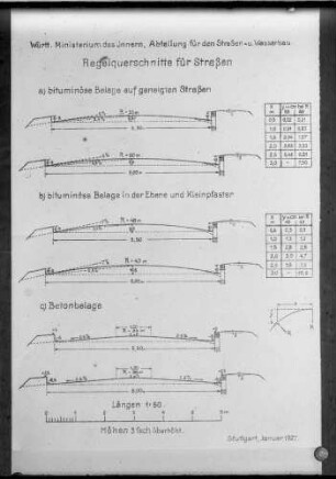
Regelquerschnitt Straßenbau
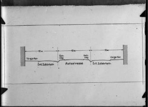
Bundesautobahn-Regelquerschnitt
Regelquerschnitt Straßenbau
Loisachregulierung - Regelquerschnitt von km 41,786 - 45,098
Regelquerschnitt
Loisachregulierung - Boschhofbrücke bei km 21,155
Loisachregulierung - Boschhofbrücke bei km 21,155
Loisachregulierung - Maxkroner Steg, bei km 28.214
Regelquerschnitt Straßenbau
Regelquerschnitt Straßenbau
Regelquerschnitt Straßenbau
Regelquerschnitt Straßenbau
Regelquerschnitt Straßenbau
Bundesautobahn-Regelquerschnitt