- Alternative title
-
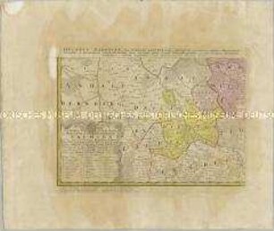
Geometrische Karte / über / das ober Amt / ZWEYBRÜCKEN
- Location
-
Deutsches Historisches Museum, Berlin
- Inventory number
-
Do 2006/1214
- Measurements
-
Höhe x Breite: 57 x 79,5 cm (Blatt)
Höhe x Breite: 50,3 x 59 cm (Karte)
Höhe x Breite: 52 x 60,5 cm (Platte)
- Material/Technique
-
Papier, Kupferstich
- Classification
-
Kartografie (Gattung)
- Subject (what)
-
Zweibrücken
- Event
-
Herstellung
- (who)
-
Geograph, Kartograf: Johann Theobald Fritsch
Stecher: Paulus Schmidt
Verlag: Simon Schropp et Co.
- (where)
-
Deutschland
- (when)
-
1794
- Rights
-
Deutsches Historisches Museum
- Last update
-
24.03.2023, 9:27 AM CET
Data provider
This object is provided by:
Stiftung Deutsches Historisches Museum. If you have any questions about the object, please contact the data provider.
Stiftung Deutsches Historisches Museum. If you have any questions about the object, please contact the data provider.
Object type
- Ämterkarte
Associated
- Geograph, Kartograf: Johann Theobald Fritsch
- Stecher: Paulus Schmidt
- Verlag: Simon Schropp et Co.
Time of origin
- 1794
Other Objects (12)
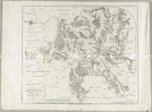
Geometrische Karte über das ober Amt Zweybrücken
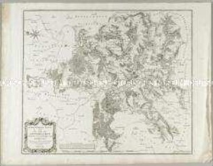
Geometrische Karte über das Ober Amt Zweybrücken

Karte der Gefürsteten Graffschaft Henneberg
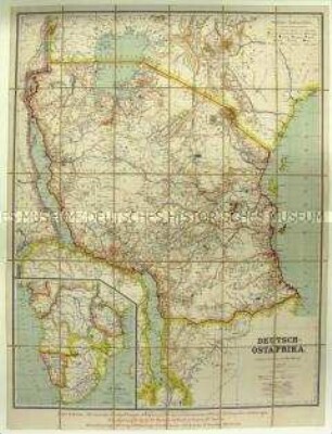
Karte der Kolonie Deutsch-Ostafrika
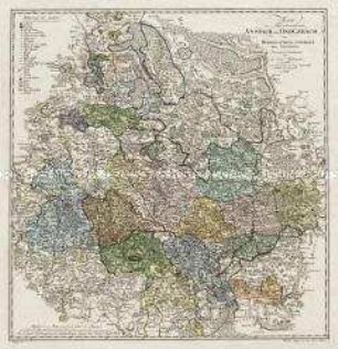
Karte vom Fürstentum Anspach oder Onolzbach
Besondere Land Karte des Herzogth. od. Churkreises Sachsen
![Karte der Umgebung von Leipzig, ca. 1:370 000, Kupferstich, 1759 : Environs de Leipzig. - [Ca. 1:370 000]. - [Paris] : [Le Rouge] , [1759]. - 1 Kt. : Kupferst. ; 22 x 21 cm](https://iiif.deutsche-digitale-bibliothek.de/image/2/0e5017a6-89b1-463d-ae77-be588bb5ed5f/full/!306,450/0/default.jpg)
Karte der Umgebung von Leipzig, ca. 1:370 000, Kupferstich, 1759 : Environs de Leipzig. - [Ca. 1:370 000]. - [Paris] : [Le Rouge] , [1759]. - 1 Kt. : Kupferst. ; 22 x 21 cm
![Karte der Ämter Wurzen, Eilenburg und Düben, ca. 1:230000, Kupferstich, 1759 : Bailliages de Wurtzen, Eilenburg et Duben. - [Ca. 1:230 000]. - [Paris] : [Le Rouge] , [1759]. - 1 Kt. : Kupferst. ; 22 x 20 cm](https://iiif.deutsche-digitale-bibliothek.de/image/2/770e375a-d9bb-4418-9e8a-bbf0354189fa/full/!306,450/0/default.jpg)
Karte der Ämter Wurzen, Eilenburg und Düben, ca. 1:230000, Kupferstich, 1759 : Bailliages de Wurtzen, Eilenburg et Duben. - [Ca. 1:230 000]. - [Paris] : [Le Rouge] , [1759]. - 1 Kt. : Kupferst. ; 22 x 20 cm
![Karte der Ämter Rochlitz, Colditz und Leissnig, ca. 1:260 000, Kupferstich, 1759 : Haute-Saxe, Bailliage De Rochliz, Coldiz Et Leissnig. - [Ca. 1:260 000]. - [Paris] : [Le Rouge] , [1759]. - 1 Kt. : Kupferst. ; 27 x 20 cm](https://iiif.deutsche-digitale-bibliothek.de/image/2/6609d286-764b-4340-8df8-b0dee5a59688/full/!306,450/0/default.jpg)
Karte der Ämter Rochlitz, Colditz und Leissnig, ca. 1:260 000, Kupferstich, 1759 : Haute-Saxe, Bailliage De Rochliz, Coldiz Et Leissnig. - [Ca. 1:260 000]. - [Paris] : [Le Rouge] , [1759]. - 1 Kt. : Kupferst. ; 27 x 20 cm
![Karte des Amtes Leipzig, ca. 1:240 000, Kupferstich, um 1720 : Leipziger Amts-Bezirk. - [Ca. 1:240 000]. - Leipzig : J. George Schreiber , [um 1720]. - 1 Kt. : Kupferst. ; 15 x 16 cm, Bildgr. 25 x 17 cm](https://iiif.deutsche-digitale-bibliothek.de/image/2/51509436-b020-4089-a653-94747d567606/full/!306,450/0/default.jpg)
Karte des Amtes Leipzig, ca. 1:240 000, Kupferstich, um 1720 : Leipziger Amts-Bezirk. - [Ca. 1:240 000]. - Leipzig : J. George Schreiber , [um 1720]. - 1 Kt. : Kupferst. ; 15 x 16 cm, Bildgr. 25 x 17 cm
![Karte vom Kreis Meißen, ca. 1:500 000, Kupferstich, vor 1745 : Der Meisnische Creys in dem Churfürstenthum Sachsen / verfertiget von Ioh. George Schreibern. - [Ca. 1:500 000]. - Leipzig , [vor 1745]. - 1 Kt. : Kupferst. ; 24 x 17 cm](https://iiif.deutsche-digitale-bibliothek.de/image/2/676e924d-bb97-4c35-aaf7-1209b631c4ed/full/!306,450/0/default.jpg)
Karte vom Kreis Meißen, ca. 1:500 000, Kupferstich, vor 1745 : Der Meisnische Creys in dem Churfürstenthum Sachsen / verfertiget von Ioh. George Schreibern. - [Ca. 1:500 000]. - Leipzig , [vor 1745]. - 1 Kt. : Kupferst. ; 24 x 17 cm
![Karte des Amtes Großenhain, ca. 1:250 000, Kupferstich, vor 1745 : Das Amt Großen-Hayn mit Zabeltitz im Meissn. Creisse gelegen. - [Ca. 1:250 000]. - Leipzig : Joh. George Schreiber , [vor 1745]. - 1 Kt. : Kupferst. ; 18 x 16 cm](https://iiif.deutsche-digitale-bibliothek.de/image/2/c28bd672-19ff-4e5c-87b4-045435a820b6/full/!306,450/0/default.jpg)
Karte des Amtes Großenhain, ca. 1:250 000, Kupferstich, vor 1745 : Das Amt Großen-Hayn mit Zabeltitz im Meissn. Creisse gelegen. - [Ca. 1:250 000]. - Leipzig : Joh. George Schreiber , [vor 1745]. - 1 Kt. : Kupferst. ; 18 x 16 cm
Geometrische Karte über das ober Amt Zweybrücken
Geometrische Karte über das Ober Amt Zweybrücken
Karte der Gefürsteten Graffschaft Henneberg
Karte der Kolonie Deutsch-Ostafrika
Karte vom Fürstentum Anspach oder Onolzbach
Besondere Land Karte des Herzogth. od. Churkreises Sachsen
Karte der Umgebung von Leipzig, ca. 1:370 000, Kupferstich, 1759 : Environs de Leipzig. - [Ca. 1:370 000]. - [Paris] : [Le Rouge] , [1759]. - 1 Kt. : Kupferst. ; 22 x 21 cm
Karte der Ämter Wurzen, Eilenburg und Düben, ca. 1:230000, Kupferstich, 1759 : Bailliages de Wurtzen, Eilenburg et Duben. - [Ca. 1:230 000]. - [Paris] : [Le Rouge] , [1759]. - 1 Kt. : Kupferst. ; 22 x 20 cm
Karte der Ämter Rochlitz, Colditz und Leissnig, ca. 1:260 000, Kupferstich, 1759 : Haute-Saxe, Bailliage De Rochliz, Coldiz Et Leissnig. - [Ca. 1:260 000]. - [Paris] : [Le Rouge] , [1759]. - 1 Kt. : Kupferst. ; 27 x 20 cm
Karte des Amtes Leipzig, ca. 1:240 000, Kupferstich, um 1720 : Leipziger Amts-Bezirk. - [Ca. 1:240 000]. - Leipzig : J. George Schreiber , [um 1720]. - 1 Kt. : Kupferst. ; 15 x 16 cm, Bildgr. 25 x 17 cm
Karte vom Kreis Meißen, ca. 1:500 000, Kupferstich, vor 1745 : Der Meisnische Creys in dem Churfürstenthum Sachsen / verfertiget von Ioh. George Schreibern. - [Ca. 1:500 000]. - Leipzig , [vor 1745]. - 1 Kt. : Kupferst. ; 24 x 17 cm