Karte / Plan
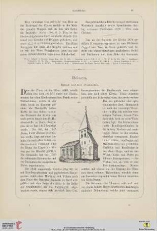
Bönen (Bönen) Ländereien der Domänenhöfe Stapel und Lohmann 1751 100 holl. Ruten = 12,8 cm 87 x 88 kol. Zeichnung Meinicke, Ingenieur KSA Nr. 1377,19
- Former reference number
-
Kartensammlung Arnsberg 1377,19
- Further information
-
Ort: Bönen, Bönen
- Context
-
Karten A (Allgemein) >> 2. Land- und Forstwirtschaft >> 2.1. Ländereien >> 2.1.1. A-K
- Holding
-
W 051 Karten A (Allgemein)
- Indexentry person
-
Lohmann, Bönen, 1751
Stapel, Bönen, 1751
- Indexentry place
-
Bönen, Bönen
Bönen, Domänenhöfe Stapel/Lohmann, Ländereien, 1751
- Date of creation
-
1751
- Other object pages
- Provenance
-
Sammlungsregistraturbildner
- Delivered via
- Last update
-
05.11.2025, 3:25 PM CET
Data provider
This object is provided by:
Landesarchiv Nordrhein-Westfalen. Abteilung Westfalen. If you have any questions about the object, please contact the data provider.
Landesarchiv Nordrhein-Westfalen. Abteilung Westfalen. If you have any questions about the object, please contact the data provider.
Object type
- Karten / Pläne
Time of origin
- 1751
Other Objects (12)

Bönen, Bahnhof Bönen
Bönen
Bönen
⟦Bönen⟧
Bönen, Poststelle I Bönen über Altenbögge

Bönen (Bönen), Teilung der Lütgenbögger Gemeinheit, Brouillonkarte
Bönen, Poststelle II Bergmannssiedlung Bönen über Hamm

Bönen (Bönen), Teilung der Lütgenbögger Gemeinheit, Reinkarte

Bönen (Bönen), Teilung der Lütgenbögger Gemeinheit, Brouillonkarte
Bönen: Organistenstelle
Friedhof Bönen
Friedhof Bönen
Bönen, Bahnhof Bönen
Bönen
Bönen
⟦Bönen⟧
Bönen, Poststelle I Bönen über Altenbögge
Bönen (Bönen), Teilung der Lütgenbögger Gemeinheit, Brouillonkarte
Bönen, Poststelle II Bergmannssiedlung Bönen über Hamm
Bönen (Bönen), Teilung der Lütgenbögger Gemeinheit, Reinkarte
Bönen (Bönen), Teilung der Lütgenbögger Gemeinheit, Brouillonkarte
Bönen: Organistenstelle
Friedhof Bönen