- Alternativer Titel
-
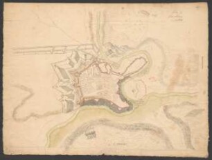
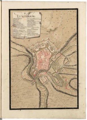
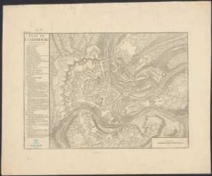
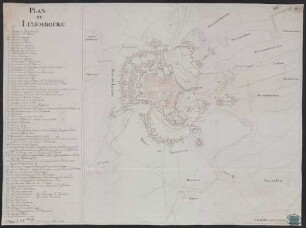
PLAN DE / LUXEMBOURG
- Standort
-
Deutsches Historisches Museum, Berlin
- Inventarnummer
-
Do 2006/333
- Maße
-
Höhe x Breite: 58 x 80 cm (Blatt)
Höhe x Breite: 36,7 x 44,3 cm (Karte)
Höhe x Breite: 38 x 54,5 cm (Platte)
- Material/Technik
-
Druckfarbe, Papier, Kupferstich
- Klassifikation
-
Kartografie (Gattung)
- Bezug (was)
-
Luxemburg
- Ereignis
-
Herstellung
- (wer)
-
Geograph, Kartograf: E. A. Thomas Jaillot?
- (wo)
-
Paris, Frankreich
- (wann)
-
1781
- Rechteinformation
-
Deutsches Historisches Museum
- Letzte Aktualisierung
-
24.03.2023, 09:29 MEZ
Datenpartner
Dieses Objekt wird bereitgestellt von:
Stiftung Deutsches Historisches Museum. Bei Fragen zum Objekt wenden Sie sich bitte an den Datenpartner.
Stiftung Deutsches Historisches Museum. Bei Fragen zum Objekt wenden Sie sich bitte an den Datenpartner.
Objekttyp
- Fortifikationsplan
Beteiligte
- Geograph, Kartograf: E. A. Thomas Jaillot?
Entstanden
- 1781
Ähnliche Objekte (12)
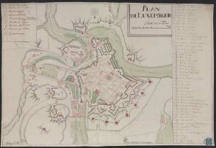
Plan de Luxembourg
Plan de Luxembourg
Plan de Luxembourg

Plan de Luxembourg. Jaillot 1781
Plan de la ville de Luxembourg
De Luxembourg
Découvrir Luxembourg : = Discover Luxembourg = Entdecken Luxembourg
![Plan de Luxembourg[...] Planche 31. Page 170.](https://iiif.deutsche-digitale-bibliothek.de/image/2/db8a6ec4-f7a0-4c87-b40d-a6ce4d54b1ce/full/!306,450/0/default.jpg)
Plan de Luxembourg[...] Planche 31. Page 170.
PLAN//DE//LUXEMBOURG - BSB Cod.icon. 180 ufr
PLAN DE LUXEMBOURG - BSB Cod.icon. 180 ufu
Memorial du Grand-Duché de Luxembourg, Luxembourg
Jardin de Luxembourg
Plan de Luxembourg
Plan de Luxembourg
Plan de Luxembourg
Plan de Luxembourg. Jaillot 1781
Plan de la ville de Luxembourg
De Luxembourg
Découvrir Luxembourg : = Discover Luxembourg = Entdecken Luxembourg
Plan de Luxembourg[...] Planche 31. Page 170.
PLAN//DE//LUXEMBOURG - BSB Cod.icon. 180 ufr
PLAN DE LUXEMBOURG - BSB Cod.icon. 180 ufu
Memorial du Grand-Duché de Luxembourg, Luxembourg