Karte / Plan
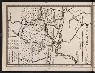
[Karte der Rheinbauarbeiten bei Niehl mit Flittarder Insel und Enklavierungskribbe]. I 20/31
- Reference number
-
RW Karten, 2324
- Dimensions
-
Höhe: 60 cm, Breite: 22 cm
- Context
-
RW Karten >> 5. Gewässer >> 5.2. Rhein >> 5.2.2. Kürzere Stromabschnitte
- Holding
-
RW Karten
- Date of creation
-
[um 1775]
- Other object pages
- Provenance
-
Diverse Registraturbildner
- Delivered via
- Last update
-
05.11.2025, 3:55 PM CET
Data provider
This object is provided by:
Landesarchiv Nordrhein-Westfalen. Abteilung Rheinland. If you have any questions about the object, please contact the data provider.
Landesarchiv Nordrhein-Westfalen. Abteilung Rheinland. If you have any questions about the object, please contact the data provider.
Object type
- Karten / Pläne
Time of origin
- [um 1775]
Other Objects (12)
20-31
20-31
20-31
20-31
20-31
20-31
20-31
20-31
20-31
20-31

20-31 Historische Theologie

20.-31. Juli 1603
20-31
20-31
20-31
20-31
20-31
20-31
20-31
20-31
20-31
20-31
20-31 Historische Theologie
20.-31. Juli 1603
20-31
20-31
20-31
20-31
20-31
20-31
20-31
20-31
20-31
20-31
20-31 Historische Theologie