Karte
Sketch of the Harbour of Monte Video and City of St. Philip shewing the Movements of the British Army in the Attack of that Place which was Taken by Storm, early in the Morning Feby. 3d. 1807 : [gewidmet:] Tucker
![Sketch of the Harbour of Monte Video and City of St. Philip shewing the Movements of the British Army in the Attack of that Place which was Taken by Storm, early in the Morning Feby. 3d. 1807 : [gewidmet:] Tucker](https://iiif.deutsche-digitale-bibliothek.de/image/2/77517150-9e07-4f56-b93f-a91890668bb0/full/!1149,610/0/default.jpg)
- Alternative title
-
Esquema de la Bahía de Montevideo y Ciudad de San Felipe mostrando los Movimientos de la Armada Británica en el ataque a esa plaza
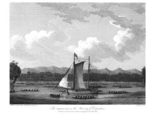
West by North, View of the City of St. Philip; Monte Video
Vista al Noroeste de la Ciudad de St. Felipe; Montevideo
- Location
-
IAI Berlin
- Extent
-
1 Kt
- Material
-
Karte
- Language
-
Spanisch
- Notes
-
Orig.-Vorlage: Kupferst. - Orig.-Gr.: 55 x 29 cm. - Maßstab in graph. Form (Yards). - Ohne Kt.-Netz. - Mit Tiefenangaben. - Mit Bergstrichen. - Mit 1 Ansicht: West by North, View of the City of St. Philip; Monte Video
- Series
-
Altkarten-Projekt des IAI
- Contributor
-
Robinson, George
Merigot, J.
Faden, William
- Published
-
Montevideo : Impresora Uruguaya Colombino , 2004
Berlin : Ibero-Amerikanisches Institut
- PURL
- Last update
-
09.05.2025, 3:04 PM CEST
Data provider
This object is provided by:
Ibero-Amerikanisches Institut - Stiftung Preußischer Kulturbesitz. If you have any questions about the object, please contact the data provider.
Ibero-Amerikanisches Institut - Stiftung Preußischer Kulturbesitz. If you have any questions about the object, please contact the data provider.
Object type
- Karte
Associated
- Robinson, George
- Merigot, J.
- Faden, William
Time of origin
- Montevideo : Impresora Uruguaya Colombino , 2004
- Berlin : Ibero-Amerikanisches Institut
Other Objects (12)

The morning of the third

The Morning of the Shepherds
Voices of the morning
Sons of the morning
Sons of the morning
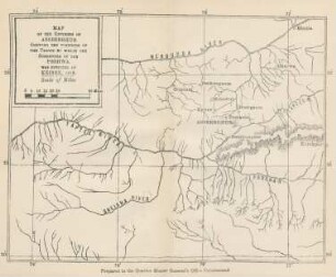
Map of the environs of Asseerghur shewing the positions of the troops ...

Grafik "The funeral of Ensign Tucker of the British Legion…"
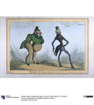
Shewing the figure - Dress of 1829
Doxology of the Morning Prayer
The Oroolong on the Morning of Departure.
Morning (Morning breaks up the unity of things)
Map of part of upper Assam. Shewing the situation of the tea districts
The morning of the third
The Morning of the Shepherds
Voices of the morning
Sons of the morning
Sons of the morning
Map of the environs of Asseerghur shewing the positions of the troops ...
Grafik "The funeral of Ensign Tucker of the British Legion…"
Shewing the figure - Dress of 1829
Doxology of the Morning Prayer
The Oroolong on the Morning of Departure.
Morning (Morning breaks up the unity of things)