Karten und Pläne
Titel: Gersfeld-Fuldaisches Gebiet mit der Lütterer Grenze. Art: Grundriss. Maßstab: 1 Ruthe = 16 Nürnberger Schuh. Historisches Territorium: Hochstift Fulda. Modernes Territorium: Landkreis Fulda
- Reference number
-
Plansammlung 10783
- Further information
-
Urheber: Hofmann, Johann, Gerichts? und Feldgeschworener
- Context
-
Plansammlung >> Plansammlung
- Holding
-
Plansammlung
- Indexentry person
-
Hofmann: Johann, Gerichts- und Feldgeschworener
- Indexentry place
-
Gersfeld (Rhön) (Lkr. Fulda, Hessen)
Fulda (Lkr. Fulda, Hessen)
- Date of creation
-
1791
- Other object pages
- Last update
-
03.04.2025, 1:41 PM CEST
Data provider
This object is provided by:
Bayerisches Hauptstaatsarchiv. If you have any questions about the object, please contact the data provider.
Bayerisches Hauptstaatsarchiv. If you have any questions about the object, please contact the data provider.
Object type
- Karten und Pläne
Time of origin
- 1791
Other Objects (12)

Titel: Ritzelshof und die Lütterer Grenze. Art: Grundriss. Historisches Territorium: Hochstift Fulda. Modernes Territorium: Landkreis Fulda
Titel: Ritzelshof und die Lütterer Grenze. Art: Grundriss. Historisches Territorium: Hochstift Fulda. Modernes Territorium: Landkreis Fulda

Der Rhönsprudel bei Lütter (Fulda-Gersfeld), 20 Minuten vom Bahnhof
Rhönbahn Fulda - Gersfeld.

Rhönbahn Fulda-Gersfeld.
Kreisbauernschaft Fulda-Gersfeld
Landkreise Fulda und Gersfeld - Landkreis Fulda
Unerlaubte Handlungen Fuldas auf Riedeselschem Territorium
2. Rhönbahn Fulda-Gersfeld.
Titel: Rittelhof und die Bechelheimische Lindenhart. Art: Grundriss. Historisches Territorium: Hochstift Fulda. Modernes Territorium: Landkreis Fulda
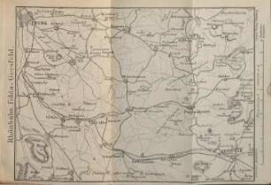
Rhönbahn Fulda-Gersfeld mit Umgebung.

7. Tour: Rhönbahn Fulda-Gersfeld
Titel: Ritzelshof und die Lütterer Grenze. Art: Grundriss. Historisches Territorium: Hochstift Fulda. Modernes Territorium: Landkreis Fulda
Titel: Ritzelshof und die Lütterer Grenze. Art: Grundriss. Historisches Territorium: Hochstift Fulda. Modernes Territorium: Landkreis Fulda
Der Rhönsprudel bei Lütter (Fulda-Gersfeld), 20 Minuten vom Bahnhof
Rhönbahn Fulda - Gersfeld.
Rhönbahn Fulda-Gersfeld.
Kreisbauernschaft Fulda-Gersfeld
Landkreise Fulda und Gersfeld - Landkreis Fulda
Unerlaubte Handlungen Fuldas auf Riedeselschem Territorium
2. Rhönbahn Fulda-Gersfeld.
Titel: Rittelhof und die Bechelheimische Lindenhart. Art: Grundriss. Historisches Territorium: Hochstift Fulda. Modernes Territorium: Landkreis Fulda
Rhönbahn Fulda-Gersfeld mit Umgebung.