Karte / Plan
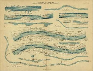
Bestimmung des Hochwasserfreigebiets der Ruhr Stromstrecke St. 63,5 bis 67. Querprofile km 63,6, 63,9, 64,2, 64,4, 64,5, 64,7, 65,2, 65,6, 65,9, 66,3, 66,5, 66,8, 67,1. Bl. 3-5, 7-10 [Bl. 2 = 4579, Bl. 6 = 3902]. Ruhrort/Düsseldorf 1. April 1901. Stelkens, Wasserbauinspektor; R. Schmidt, Regierungsbaumeister; ..., Oberdeichinsp.
- Reference number
-
RW Karten, 4576 - a
- Dimensions
-
Höhe: 64 cm, Breite: 50 cm, Maßstab: 1 : 1250 (L), 1 : 100 (H)
- Context
-
RW Karten >> 5. Gewässer >> 5.3. Ruhr >> 5.3.3. Hochwasserfreigebiete
- Holding
-
RW Karten
- Date of creation
-
1901
- Other object pages
- Provenance
-
Diverse Registraturbildner
- Delivered via
- Last update
-
05.11.2025, 3:12 PM CET
Data provider
This object is provided by:
Landesarchiv Nordrhein-Westfalen. Abteilung Rheinland. If you have any questions about the object, please contact the data provider.
Landesarchiv Nordrhein-Westfalen. Abteilung Rheinland. If you have any questions about the object, please contact the data provider.
Object type
- Karten / Pläne
Time of origin
- 1901
Other Objects (12)

§ 61 / § 62 / § 63 / § 64 / § 65 / § 66 / § 67 / § 68

Reiseberichte, Reg. Nr. 96/64, 100/64, 95/64, 105/64, 109/64, 108/65, 174/63, 57/63, 73/64, 208/65, 209/65, 210/65, 241/65, 247/65, 114/65, 113/65, 78/64, 50/63, 44/63
Reiseberichte, Reg. Nr. 257/65, 216/65, 110/65, 139/65, 135/65, 7/64, 20/64, 15/64, 10/64, 5/64, 41/63, 169/63, 47/63, 106/64, 177/63
Bl. 63/64
Luckenwalde, Parkstraße 64 & 65 & 66
Speyer, Maximilianstr. 64 - 65 - 66.
Motor P 50, P 60, P 63/64, P 65/66
Motor P 50, P 60, P 63/64, P 65/66
Motor P 50, P 60, P 63/64, P 65/66
Motor P 50, P 60, P 63/64, P 65/66
Motor P 50, P 60, P 63/64, P 65/66
Motor P 50, P 60, P 63/64, P 65/66
§ 61 / § 62 / § 63 / § 64 / § 65 / § 66 / § 67 / § 68
Reiseberichte, Reg. Nr. 96/64, 100/64, 95/64, 105/64, 109/64, 108/65, 174/63, 57/63, 73/64, 208/65, 209/65, 210/65, 241/65, 247/65, 114/65, 113/65, 78/64, 50/63, 44/63
Reiseberichte, Reg. Nr. 257/65, 216/65, 110/65, 139/65, 135/65, 7/64, 20/64, 15/64, 10/64, 5/64, 41/63, 169/63, 47/63, 106/64, 177/63
Bl. 63/64
Luckenwalde, Parkstraße 64 & 65 & 66
Speyer, Maximilianstr. 64 - 65 - 66.
Motor P 50, P 60, P 63/64, P 65/66
Motor P 50, P 60, P 63/64, P 65/66
Motor P 50, P 60, P 63/64, P 65/66
Motor P 50, P 60, P 63/64, P 65/66
Motor P 50, P 60, P 63/64, P 65/66