
- Location
-
IAI Berlin
- Extent
-
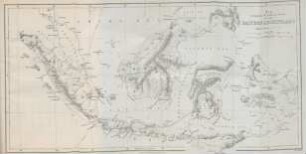
1 Kt, [Ca. 1:510.000]
- Material
-
Karte
- Language
-
Englisch
- Notes
-
Orig.-Vorlage: Lithogr. - Maßstab in graph. Form (Miles, Kilomètres). - Mit Erl. auf dem Kt.-Feld. - Inselkt.
- Series
-
Altkarten-Projekt des IAI
- Contributor
- Published
-
[S.l.] , 1990
Berlin : Ibero-Amerikanisches Institut
- PURL
- Last update
-
09.05.2025, 3:03 PM CEST
Data provider
This object is provided by:
Ibero-Amerikanisches Institut - Stiftung Preußischer Kulturbesitz. If you have any questions about the object, please contact the data provider.
Ibero-Amerikanisches Institut - Stiftung Preußischer Kulturbesitz. If you have any questions about the object, please contact the data provider.
Object type
- Karte
Associated
Time of origin
- [S.l.] , 1990
- Berlin : Ibero-Amerikanisches Institut
Other Objects (12)

Travels amongst the Great Andes of the Equator by Edward Whymper, 1

Travels amongst the Great Andes of the Equator by Edward Whymper, 2
Map to illustrate Mr. Bickmore's travels in the Eastern Archipelago
Naar den equator

Travels into Chile, over the Andes : Illustrated with 30 plates

Introduction : The Equator-S mission

Last rambles amongst the Indians of the Rocky Mountains and the Andes
![[Ansiedlung der] Equator Aircraft GmbH (Flugzeugbau)](/assets/placeholder/searchResultMediaNoDigitisedMedia.png)
[Ansiedlung der] Equator Aircraft GmbH (Flugzeugbau)
10 years equator principles: a critical appraisal

Poesie : Illustrate, 2

Poesie : Illustrate, 1

North Borneo : explorations and adventures on the Equator
Travels amongst the Great Andes of the Equator by Edward Whymper, 1
Travels amongst the Great Andes of the Equator by Edward Whymper, 2
Map to illustrate Mr. Bickmore's travels in the Eastern Archipelago
Naar den equator
Travels into Chile, over the Andes : Illustrated with 30 plates
Introduction : The Equator-S mission
Last rambles amongst the Indians of the Rocky Mountains and the Andes
[Ansiedlung der] Equator Aircraft GmbH (Flugzeugbau)
10 years equator principles: a critical appraisal
Poesie : Illustrate, 2
Poesie : Illustrate, 1