- Reference number
-
StAM, Plansammlung 958
- Former reference number
-
AR 40/135
- Dimensions
-
41,5 cm x 58 cm
- Formal description
-
1/2 Meile = 20 cm; Federzeichnung koloriert
- Language of the material
-
deutsch
- Further information
-
Urheber: Zeichner: MonogrammAW ?
- Context
-
Plansammlung >> Plansammlung >> 1. Plansammlung 1-4191 (Retrokonvertiertes Findmittel) >> 1.1. Allgemeine Plansammlung
- Holding
-
StAM, Plansammlung Plansammlung
- Date of creation
-
um 1800
- Other object pages
- Last update
-
22.04.2025, 1:53 PM CEST
Data provider
This object is provided by:
Staatsarchiv München. If you have any questions about the object, please contact the data provider.
Staatsarchiv München. If you have any questions about the object, please contact the data provider.
Object type
- Karten und Pläne
Time of origin
- um 1800
Other Objects (12)

Kastl (LK Altötting). Pläne vom Kirchturmneubau in Kastl
Kastl (LK Altötting). Pläne vom Kirchturmneubau in Kastl
Bezirksstraße Altötting-Kastl-Tittmoning
Pfarreien, Kastl, Pfarrei
Straße von Altötting über Kastl nach Tittmoning
Grundrentenüberweisung der Pfarrei Kastl
Zehentfixation der Pfarrei Kastl
Organisation der Pfarrei Kastl
Erledigung der Pfarrei Kastl
Besetzung der Pfarrei Kastl
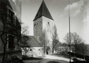
Kastl, Klosterburg : Kastl. Klosterburg. Torturm
Kastl
Kastl (LK Altötting). Pläne vom Kirchturmneubau in Kastl
Kastl (LK Altötting). Pläne vom Kirchturmneubau in Kastl
Bezirksstraße Altötting-Kastl-Tittmoning
Pfarreien, Kastl, Pfarrei
Straße von Altötting über Kastl nach Tittmoning
Grundrentenüberweisung der Pfarrei Kastl
Zehentfixation der Pfarrei Kastl
Organisation der Pfarrei Kastl
Erledigung der Pfarrei Kastl
Besetzung der Pfarrei Kastl
Kastl, Klosterburg : Kastl. Klosterburg. Torturm