Karten und Pläne
Geographisch-Statistisch-historischer Atlas der Staaten des Deutschen Bundes. Herzogtum Altenburg, Anhalt, Herzogtum Coburg-Gotha, Meinigen-Hildburghausen
- Reference number
-
StAM, Kartensammlung 203
- Former reference number
-
K 329
- Dimensions
-
47 cm x 40 cm
- Formal description
-
5 Blatt; Kupferstiche koloriert
- Language of the material
-
deutsch
- Context
-
Kartensammlung >> Kartensammlung >> 1. Kartensammlung Bd. 1-4 (retrokonvertiert)
- Holding
-
Kartensammlung
- Date of creation
-
Weimar 1827
- Other object pages
- Last update
-
22.04.2025, 1:55 PM CEST
Data provider
This object is provided by:
Staatsarchiv München. If you have any questions about the object, please contact the data provider.
Staatsarchiv München. If you have any questions about the object, please contact the data provider.
Object type
- Karten und Pläne
Time of origin
- Weimar 1827
Other Objects (12)
Herzogtum Sachsen-Meinigen.

Auswanderungsgesuch Oppelt Maria, Eggolsheim, ins Herzogtum Coburg-Gotha
Gutachten über die Finanzverhätnisse des Herzogtums Sachsen Coburg-Gotha
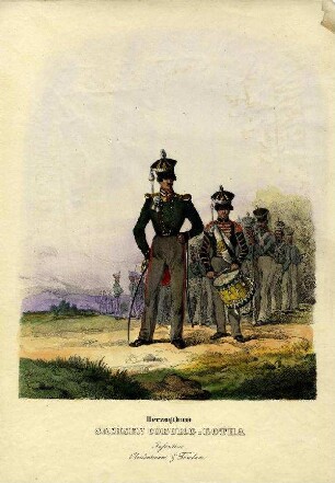
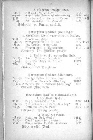
Uniformbild, Soldat der Infanterie vom Herzogtum Sachsen Coburg-Gotha
Uniformbild, Soldat der Infanterie vom Herzogtum Sachsen Coburg-Gotha

Uniformbild, Soldat der Infanterie vom Herzogtum Sachsen Coburg-Gotha
Mitteilung eines Exemplars der preußischen Generalstabskarte des Herzogtums Coburg-Gotha
Verzeichnis der Postanstalten mit zusätzlicher Bezeichnung im Herzogtum Coburg-Gotha
Die gegenseitige Besteuerung der Eigentumsrechte mit dem Herzogtum Sachsen-Meinigen
Erteilung von Heimat- und Übernahmescheinen zum Aufenthalt im Herzogtum Coburg-Gotha
Pressegesetzgebung in den sächsischen Herzogtümern Weimar-Eisenach, Altenburg und Coburg-Gotha
Karte des Herzogtums Sachsen-Hildburghausen
Herzogtum Sachsen-Meinigen.
Auswanderungsgesuch Oppelt Maria, Eggolsheim, ins Herzogtum Coburg-Gotha
Gutachten über die Finanzverhätnisse des Herzogtums Sachsen Coburg-Gotha
Uniformbild, Soldat der Infanterie vom Herzogtum Sachsen Coburg-Gotha
Uniformbild, Soldat der Infanterie vom Herzogtum Sachsen Coburg-Gotha
Uniformbild, Soldat der Infanterie vom Herzogtum Sachsen Coburg-Gotha
Mitteilung eines Exemplars der preußischen Generalstabskarte des Herzogtums Coburg-Gotha
Verzeichnis der Postanstalten mit zusätzlicher Bezeichnung im Herzogtum Coburg-Gotha
Die gegenseitige Besteuerung der Eigentumsrechte mit dem Herzogtum Sachsen-Meinigen
Erteilung von Heimat- und Übernahmescheinen zum Aufenthalt im Herzogtum Coburg-Gotha
Pressegesetzgebung in den sächsischen Herzogtümern Weimar-Eisenach, Altenburg und Coburg-Gotha