Karten und Pläne
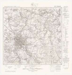
Topografische Karte 1:25.000, 7419 Herrenberg
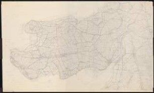
Begleittext: eine schwarze Linie von Hand hinzugefügt und Biotope oder Landschaftselemente (?) mit Nummern
- Reference number
-
A 616/374
- Further information
-
Maßstab: 1:25000
- Context
-
A 616 Pläne zur Landschaftsplanung
- Holding
-
A 616 Pläne zur Landschaftsplanung
- Other object pages
- Last update
-
29.04.2025, 8:35 AM CEST
Data provider
This object is provided by:
Stadtarchiv Tübingen. If you have any questions about the object, please contact the data provider.
Stadtarchiv Tübingen. If you have any questions about the object, please contact the data provider.
Object type
- Karte und Plan
Other Objects (12)

Herrenberg SW; Vergrößerung der Topografische Karte 1:25.000 Blatt 7419 ( 95)
Topografische Karten 1:25000 (Bestand)
Topografische Karte 1:25.000, 7520 Mössingen
Topografische Karte 1:25.000, 7420 Tübingen
Topografische Karte 1:25.000, Blatt Neuss 2779
Mühlenbach; Vergrößerung der Topografische Karte 1:25.000 Umgebungskarten
Ludwigsburg; Vergrößerung der Topografische Karte 1:25.000 Umgebungskarten
Planung für Westerhever: Planungsunterlage: Topografische Karte 1:25000
Topografische Karte 1:25.000, 7519 Rottenburg am Neckar
Gschwend; Vergrößerung der Topografische Karte 1:25.000 Umgebungskarten
Evangelische Kirche, Detmold-Hiddesen: Topografische Karte 1:25000
Topografische Karte der Langkofel- und Sellagruppe (M. 1:25.000)
Herrenberg SW; Vergrößerung der Topografische Karte 1:25.000 Blatt 7419 ( 95)
Topografische Karten 1:25000 (Bestand)
Topografische Karte 1:25.000, 7520 Mössingen
Topografische Karte 1:25.000, 7420 Tübingen
Topografische Karte 1:25.000, Blatt Neuss 2779
Mühlenbach; Vergrößerung der Topografische Karte 1:25.000 Umgebungskarten
Ludwigsburg; Vergrößerung der Topografische Karte 1:25.000 Umgebungskarten
Planung für Westerhever: Planungsunterlage: Topografische Karte 1:25000
Topografische Karte 1:25.000, 7519 Rottenburg am Neckar
Gschwend; Vergrößerung der Topografische Karte 1:25.000 Umgebungskarten
Evangelische Kirche, Detmold-Hiddesen: Topografische Karte 1:25000