Karte / Plan
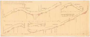
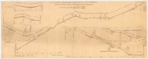
Ahlen, Längenprofile zum Bebauungsplan für das Gebiet zwischen Eisenbahn der Süd- und Kühl-Strasse, Ostenpromenade und Oststr. - Blatt 2
- Reference number
-
S 07 Kartensammlung, 968
- Dimensions
-
67x48 cm
- Formal description
-
Tuschezeichnung; Der Stadtbaumeister, Ahlen
- Material
-
Papier auf Leinen
- Notes
-
Tusche schwarz, rot; coloriert. Stempel, Unterschriften
- Further information
-
Ort: Ahlen
Maßstab: 1:1000 (Längen); 1:100 (Höhen)
- Context
-
Kartensammlung >> Karten und Pläne >> Bebauungs- und Fluchtlinienpläne >> Ahlen
- Holding
-
S 07 Kartensammlung Kartensammlung
- Date of creation
-
1915
- Other object pages
- Delivered via
- Last update
-
05.11.2025, 4:20 PM CET
Data provider
This object is provided by:
Kreis Warendorf. Kreisarchiv, Kreisverwaltung. If you have any questions about the object, please contact the data provider.
Kreis Warendorf. Kreisarchiv, Kreisverwaltung. If you have any questions about the object, please contact the data provider.
Object type
- Karten und Pläne
Time of origin
- 1915
Other Objects (12)

Stadt Ahlen. Längenprofile.
Bebauungsplan Rodleben. Längenprofile
Ahlen Querprofile zum Bebauungsplan für das Gebiet zwischen Eisenbahn der Süd- und Kühl-Strasse, Ostenpromenade und Ost-Str. - Blatt 5.
Bebauungsplan für Leopoldshall. Längenprofile
Ahlen Längenprofile zum Bebauungsplan für das Gebiet zwischen Eisenbahn der Süd- und Kühl-Strasse, Ostenpromenade und Ost-Strasse. - Blatt 4
Ahlen Längenprofile zum Bebauungsplan für das Gebiet zwischen Eisenbahn der Süd- und Kühl-Strasse, Ostenpromenade und Ost-Strasse. - Blatt 3.
Parkplatz I (Oststr.), II (Schule), III (Oststr.], IV (Oststr.]
Oststr.

Bebauungsplan Bamberg: Längenprofile 1:2000, 1:200
Bebauungsplan Bamberg: Längenprofile 1:2000, 1:200
Bebauungsplan Bamberg: Längenprofile 1:2000, 1:200
Oststr. 14
Stadt Ahlen. Längenprofile.
Bebauungsplan Rodleben. Längenprofile
Ahlen Querprofile zum Bebauungsplan für das Gebiet zwischen Eisenbahn der Süd- und Kühl-Strasse, Ostenpromenade und Ost-Str. - Blatt 5.
Bebauungsplan für Leopoldshall. Längenprofile
Ahlen Längenprofile zum Bebauungsplan für das Gebiet zwischen Eisenbahn der Süd- und Kühl-Strasse, Ostenpromenade und Ost-Strasse. - Blatt 4
Ahlen Längenprofile zum Bebauungsplan für das Gebiet zwischen Eisenbahn der Süd- und Kühl-Strasse, Ostenpromenade und Ost-Strasse. - Blatt 3.
Parkplatz I (Oststr.), II (Schule), III (Oststr.], IV (Oststr.]
Oststr.
Bebauungsplan Bamberg: Längenprofile 1:2000, 1:200
Bebauungsplan Bamberg: Längenprofile 1:2000, 1:200
Bebauungsplan Bamberg: Längenprofile 1:2000, 1:200