Karte / Plan
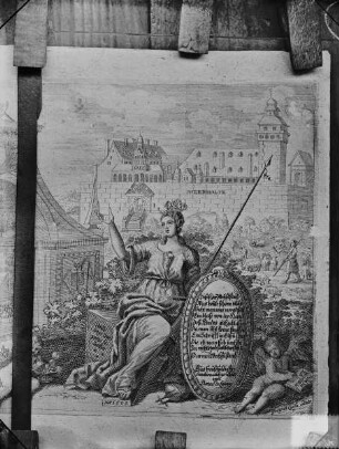
Arenshorst (Bohmte)? Schloß und geteilte Ländereien 1.H. 18.Jh. o.M. 29 x 17 kol. Zeichnung Schloßansicht aus der Vogelschau Ledebur-Crollage K Nr. 13
- Former reference number
-
Ledebur K 13
- Further information
-
Ort: Arenshorst, Bohmte
- Context
-
Karten A (Allgemein) >> 2. Land- und Forstwirtschaft >> 2.1. Ländereien >> 2.1.1. A-K
- Holding
-
W 051 Karten A (Allgemein)
- Indexbegriff subject
-
Ansicht, Schloß Arenshorst, 1725
- Indexentry place
-
Arenshorst, Bohmte
Arenshorst, Schloß, Ländereien, 1725
Arenshorst, Schloßansicht, 1725
- Date of creation
-
1725
- Other object pages
- Provenance
-
Sammlungsregistraturbildner
- Delivered via
- Last update
-
05.11.2025, 3:16 PM CET
Data provider
This object is provided by:
Landesarchiv Nordrhein-Westfalen. Abteilung Westfalen. If you have any questions about the object, please contact the data provider.
Landesarchiv Nordrhein-Westfalen. Abteilung Westfalen. If you have any questions about the object, please contact the data provider.
Object type
- Karten / Pläne
Time of origin
- 1725
Other Objects (12)

Katasterauszüge Arenshorst und Crollage

Herringhausen (Bohmte) Grundstücke des Gutes Arenshorst Katasterauszug 1881 1 : 2000 65 x 94 Zeichnung von Ledebur-Crollage

Herringhausen (Bohmte) Grundstücke des Gutes Arenshorst Katasterauszug 1881 1 : 2000 65 x 94 Zeichnung von Ledebur-Crollage

Herringhausen (Bohmte) Grundstücke des Gutes Arenshorst Katasterauszug 1881 1 : 2000 65 x 94 Zeichnung von Ledebur-Crollage

Arenshorst (Bohmte) Wirtschafts- und Bestandskarte der Forsten des Rittergutes Arenshorst 1920 1 : 10 000 44 x 42,5 Druck Ledebur-Crollage K Nr. 4

Herringhausen (Bohmte) Grundstücke des Gutes Arenshorst Katasterauszug 1881 1 : 2000 64 x 96 Zeichnung, Kopie von Ledebur-Crollage

Herringhausen (Bohmte) Grundstücke des Gutes Arenshorst Katasterauszug 1887 1 : 2000 90 x 76 kol. Zeichnung von Ledebur-Crollage
Hypothekarische Eintragung des Gesamtlehens Crollage-Arenshorst-Mühlenburg
Prozeß Kolon Reme zu Bohmte ./. v. Ledebur zu Arenshorst

Stirpe-Oelingen (Bohmte) Hitz-Jöstinghausen (Ostercappeln) Grundstücke des Gutes Arenshorst Katasterauszug 1881 1 : 2000 65 x 47 von Ledebur-Crollage
Schlossansicht
Schlossansicht
Katasterauszüge Arenshorst und Crollage
Herringhausen (Bohmte) Grundstücke des Gutes Arenshorst Katasterauszug 1881 1 : 2000 65 x 94 Zeichnung von Ledebur-Crollage
Herringhausen (Bohmte) Grundstücke des Gutes Arenshorst Katasterauszug 1881 1 : 2000 65 x 94 Zeichnung von Ledebur-Crollage
Herringhausen (Bohmte) Grundstücke des Gutes Arenshorst Katasterauszug 1881 1 : 2000 65 x 94 Zeichnung von Ledebur-Crollage
Arenshorst (Bohmte) Wirtschafts- und Bestandskarte der Forsten des Rittergutes Arenshorst 1920 1 : 10 000 44 x 42,5 Druck Ledebur-Crollage K Nr. 4
Herringhausen (Bohmte) Grundstücke des Gutes Arenshorst Katasterauszug 1881 1 : 2000 64 x 96 Zeichnung, Kopie von Ledebur-Crollage
Herringhausen (Bohmte) Grundstücke des Gutes Arenshorst Katasterauszug 1887 1 : 2000 90 x 76 kol. Zeichnung von Ledebur-Crollage
Hypothekarische Eintragung des Gesamtlehens Crollage-Arenshorst-Mühlenburg
Prozeß Kolon Reme zu Bohmte ./. v. Ledebur zu Arenshorst
Stirpe-Oelingen (Bohmte) Hitz-Jöstinghausen (Ostercappeln) Grundstücke des Gutes Arenshorst Katasterauszug 1881 1 : 2000 65 x 47 von Ledebur-Crollage
Schlossansicht