Karte / Plan
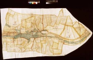
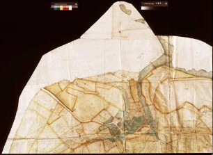
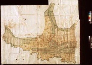
Brouillon- und (Rein-)Karte von der herrschaftl. Meierei im Amt Sternberg,. Inselkarte
- Reference number
-
D 73, 4/6614
- Dimensions
-
Höhe: 52, Breite: 76, Maßstab: ca. 1:2.895
- Context
-
Allgemeine Kartensammlung (bisherige Kartei) >> 22. Tit. 4 (noch nicht klassifiziert) >> 22.18. Nr. 6601 - 6800
- Holding
-
D 73 Allgemeine Kartensammlung (bisherige Kartei)
- Date of creation
-
1845/1847
- Other object pages
- Provenance
-
Behörden, Institutionen, Einzelpersonen (Sammlungen)
- Delivered via
- Last update
-
05.11.2025, 3:34 PM CET
Data provider
This object is provided by:
Landesarchiv Nordrhein-Westfalen. Abteilung Ostwestfalen-Lippe. If you have any questions about the object, please contact the data provider.
Landesarchiv Nordrhein-Westfalen. Abteilung Ostwestfalen-Lippe. If you have any questions about the object, please contact the data provider.
Object type
- Karten / Pläne
Time of origin
- 1845/1847
Other Objects (12)

Brouillon- und (Rein-)Karte von der herrschaftl. Meierei im Amt Sternberg,. Inselkarte
Reinkarte der herrschaftlichen Meierei Schieder mit dem Noltehof;. Inselkarte
Annelsbacher Brouillon oder Konzeptkarte (Inselkarte)
Rimhorner Brouillon oder Konzeptkarte (Inselkarte)
Dusenbacher Brouillon oder Konzeptkarte (Inselkarte)

Pfirschbacher (Persbacher) Brouillon oder Konzeptkarte (Inselkarte)
(Brouillon-)Karte der Oerlinhauser Senne; Inselkarte
Herrschaftl. Meierei zu Bissingen
Herrschaftl. Meierei zu Bissingen
Herrschaftl. Meierei zu Bissingen
Herrschaftl. Meierei zu Kochendorf
Karte über den so genannten Ochsenkamp; herrschaftl. Ländereien der ehemaligen Meierei Veldrom,. Inselkarte, Brouillonkarte
Brouillon- und (Rein-)Karte von der herrschaftl. Meierei im Amt Sternberg,. Inselkarte
Reinkarte der herrschaftlichen Meierei Schieder mit dem Noltehof;. Inselkarte
Annelsbacher Brouillon oder Konzeptkarte (Inselkarte)
Rimhorner Brouillon oder Konzeptkarte (Inselkarte)
Dusenbacher Brouillon oder Konzeptkarte (Inselkarte)
Pfirschbacher (Persbacher) Brouillon oder Konzeptkarte (Inselkarte)
(Brouillon-)Karte der Oerlinhauser Senne; Inselkarte
Herrschaftl. Meierei zu Bissingen
Herrschaftl. Meierei zu Bissingen
Herrschaftl. Meierei zu Bissingen
Herrschaftl. Meierei zu Kochendorf