Karte / Plan
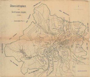
Übersichtsplan des Stadtkreises Sterkrade. Kriegsausgabe 1918. Druck C.G.Blanckertz, Düsseldorf
- Reference number
-
RW Karten, 3742
- Dimensions
-
Höhe: 135 cm, Breite: 87, Maßstab: 1:10.000
- Notes
-
Mit Straßenverzeichnis
- Context
-
RW Karten >> 6. Siedlungen >> 6.1. Stadtpläne >> 6.1.56. Sterkrade
- Holding
-
RW Karten
- Date of creation
-
1918
- Other object pages
- Provenance
-
Diverse Registraturbildner
- Delivered via
- Last update
-
05.11.2025, 3:57 PM CET
Data provider
This object is provided by:
Landesarchiv Nordrhein-Westfalen. Abteilung Rheinland. If you have any questions about the object, please contact the data provider.
Landesarchiv Nordrhein-Westfalen. Abteilung Rheinland. If you have any questions about the object, please contact the data provider.
Object type
- Karten / Pläne
Time of origin
- 1918
Other Objects (12)
Übersichtsplan des Stadtkreises Siegen

Übersichtsplan des Stadtkreises Schwedt

Übersichtsplan des Stadtkreises Siegen
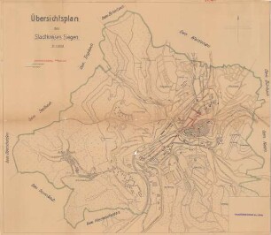
Übersichtsplan des Stadtkreises Siegen

Kriegsausgabe für April bis September 1918.

Kriegsausgabe für Januar bis März 1918
Kriegsausgabe.- Radoschkowitschi - Minsk von 1918|1 : 100 000
Reclams Universum Kriegsausgabe
Der Türmer, Kriegsausgabe

Bischofsteiner Chronik : Kriegsausgabe
Der Türmer : Kriegsausgabe
Der Türmer : Kriegsausgabe
Übersichtsplan des Stadtkreises Siegen
Übersichtsplan des Stadtkreises Schwedt
Übersichtsplan des Stadtkreises Siegen
Übersichtsplan des Stadtkreises Siegen
Kriegsausgabe für April bis September 1918.
Kriegsausgabe für Januar bis März 1918
Kriegsausgabe.- Radoschkowitschi - Minsk von 1918|1 : 100 000
Reclams Universum Kriegsausgabe
Der Türmer, Kriegsausgabe
Bischofsteiner Chronik : Kriegsausgabe
Der Türmer : Kriegsausgabe