- Reference number
-
WHK 10/2
- Dimensions
-
110x850 mm
- Notes
-
Blatt lose
- Further information
-
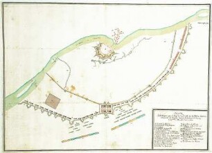
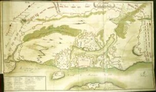
Identifikation (Karte/Plan): Originaltitel: Carte particuliere du cours de la Vistulle et du Nogat depuis la pointe du montau jusques à la mer des verders de Dantzich, d'Elbing et de Marienbourg
Identifikation (Karte/Plan): Inhaltliche Beschreibung: Weichselmündung und Frisches Haff, Danzig, Elbing und Marienburg
Identifikation (Karte/Plan): Inhaltliche Beschreibung: ausführliche Legende
Weitere Angaben (Karte/Plan): Maßstab: [ca. 1:50.000]
Weitere Angaben (Karte/Plan): Ausführung: Handzeichnung, koloriert
Weitere Angaben (Karte/Plan): Blattzahl: 1
- Context
-
Wilhelmshöher Kriegskarten >> Einzelne Kriege und Schlachtordnungen >> WHK 10 Nordischer Krieg von 1700-1719
- Holding
-
WHK Wilhelmshöher Kriegskarten
- Creator
-
Levée par Ordre de S.S.E de Brandenbourg par Montargues, Capitaine d'Infanterie et Ingenieur ordinaire
- Date of creation
-
[1680-1700]
- Other object pages
- Last update
-
10.06.2025, 9:13 AM CEST
Data provider
This object is provided by:
Hessisches Staatsarchiv Marburg. If you have any questions about the object, please contact the data provider.
Hessisches Staatsarchiv Marburg. If you have any questions about the object, please contact the data provider.
Object type
- Karte/Plan
Associated
- Levée par Ordre de S.S.E de Brandenbourg par Montargues, Capitaine d'Infanterie et Ingenieur ordinaire
Time of origin
- [1680-1700]
Other Objects (12)
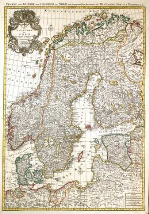
WHK 10 Nordischer Krieg von 1700-1719: Nordeuropäische Monarchien Dänemark, Schweden und Norwegen, 1700-1719
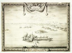
WHK 10 Nordischer Krieg von 1700-1719: Seeschlacht bei Elfsburg, 1719

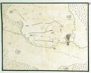
WHK 10 Nordischer Krieg von 1700-1719: Schlachtordnung der polnisch-deutschen Armee, 1700
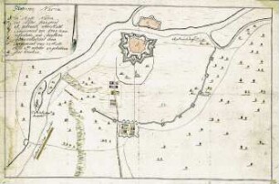
WHK 10 Nordischer Krieg von 1700-1719: Belagerung von Narwa (Narva), Oktober 1700
WHK 10 Nordischer Krieg von 1700-1719: Feldlager der Alliierten bei Oldesloe, 1700
WHK 10 Nordischer Krieg von 1700-1719: Belagerung von Narwa (Narva), 20. November 1700
WHK 10 Nordischer Krieg von 1700-1719: Belagerung von Narwa (Narva) durch die Schweden, 1700
WHK 10 Nordischer Krieg von 1700-1719: Belagerung von Narwa (Narva) durch die Schweden, 1700
WHK 10 Nordischer Krieg von 1700-1719: Belagerung von Narwa (Narva) durch die Schweden, 1700
WHK 10 Nordischer Krieg von 1700-1719: Belagerung von Stralsund, 1715
WHK 10 Nordischer Krieg von 1700-1719: Belagerung von Stralsund, 1715
WHK 10 Nordischer Krieg von 1700-1719: Belagerung von Stralsund, 1715
WHK 10 Nordischer Krieg von 1700-1719: Nordeuropäische Monarchien Dänemark, Schweden und Norwegen, 1700-1719
WHK 10 Nordischer Krieg von 1700-1719: Seeschlacht bei Elfsburg, 1719
WHK 10 Nordischer Krieg von 1700-1719: Schlachtordnung der polnisch-deutschen Armee, 1700
WHK 10 Nordischer Krieg von 1700-1719: Belagerung von Narwa (Narva), Oktober 1700
WHK 10 Nordischer Krieg von 1700-1719: Feldlager der Alliierten bei Oldesloe, 1700
WHK 10 Nordischer Krieg von 1700-1719: Belagerung von Narwa (Narva), 20. November 1700
WHK 10 Nordischer Krieg von 1700-1719: Belagerung von Narwa (Narva) durch die Schweden, 1700
WHK 10 Nordischer Krieg von 1700-1719: Belagerung von Narwa (Narva) durch die Schweden, 1700
WHK 10 Nordischer Krieg von 1700-1719: Belagerung von Narwa (Narva) durch die Schweden, 1700
WHK 10 Nordischer Krieg von 1700-1719: Belagerung von Stralsund, 1715
WHK 10 Nordischer Krieg von 1700-1719: Belagerung von Stralsund, 1715