Landkarte
Karte: Partie occidentale de la Nouvelle France ou du Canada (in zwei Teilen); Nürnberg, 1755
- Location
-
Deutsches Historisches Museum, Berlin
- Inventory number
-
Do 54/1629
- Measurements
-
Höhe x Breite: 49 x 57 cm, Höhe x Breite: 50 x 58 cm
- Material/Technique
-
Papier, Kupferstich
- Classification
-
Kartografie (Gattung)
- Subject (what)
-
Bellin
Karte
Nürnberg
- Event
-
Herstellung
- (who)
-
Stecher: Jacques Nicolas Bellin
Verlag: Homannsche Erben
- (where)
-
Nürnberg, Deutschland [historisch: Bayern, Kurfürstentum]
- (when)
-
1755
- Rights
-
Deutsches Historisches Museum
- Last update
-
24.03.2023, 9:30 AM CET
Data provider
This object is provided by:
Stiftung Deutsches Historisches Museum. If you have any questions about the object, please contact the data provider.
Stiftung Deutsches Historisches Museum. If you have any questions about the object, please contact the data provider.
Object type
- Landkarte
Associated
- Stecher: Jacques Nicolas Bellin
- Verlag: Homannsche Erben
Time of origin
- 1755
Other Objects (12)

Karte: Partie orientale de la Nouvelle France ou du Canada; Nürnberg 1755

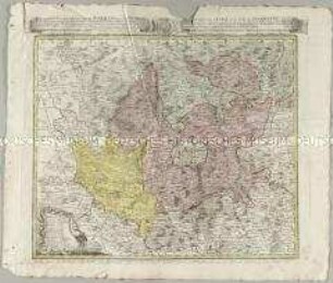
Tabula Geographica Totam Borussiam ut et Districtum Notecensem. Mit einer Nebenkarte: Charte welche den Netz District vorstellet
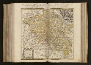
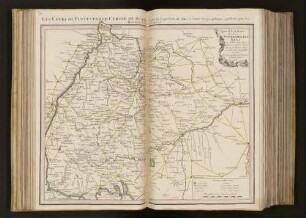
Geographische Verzeichnung des Bvdissinischen Creises in dem Marggrafthum Ober Lavsitz
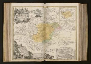
Atlas Regni Bohemiae: Repraesentatio Geographica Circuli Egerani, nec non Elnbogensis / Carte du Territoire d'Egra, & du Cercle d'Elnbogue
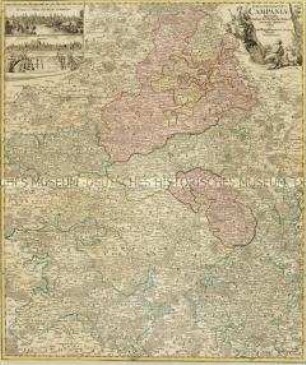
Tabula Geographica Campaniae. Mit zwei Nebenkarten: Reims und Troyes
Pläne der kanadischen Städte Louisburg, Québec und Halifax unter französischer und englischer Herrschaft
![Stadtplan und Ansicht von Mannheim, ca. 1:15 000, Kupferst., um 1740 : Hodierna sedes Electoris Palatini Manheimium Ichno- et Scenographice novissime exhibitum / Prostat In Officina Homanniana. - Circa 1:15 000 [Nürnberg] : Officina Homanniana, [um 1740]. - 1 Karte : Kupferdruck, teilweise flächenkoloriert ; Bildgröße 48 x 57 cm, Blattgröße 55 x 64 cm // NO oben. - Windrose unten links. - Titelkartusche rechts Mitte. - Mit einer Ansicht unten unter Kartenbild:Prospect der Churf. Residenz St. Manheim](https://iiif.deutsche-digitale-bibliothek.de/image/2/1331c78a-c92e-456b-9be1-3dcb5bbfc98e/full/!306,450/0/default.jpg)
Stadtplan und Ansicht von Mannheim, ca. 1:15 000, Kupferst., um 1740 : Hodierna sedes Electoris Palatini Manheimium Ichno- et Scenographice novissime exhibitum / Prostat In Officina Homanniana. - Circa 1:15 000 [Nürnberg] : Officina Homanniana, [um 1740]. - 1 Karte : Kupferdruck, teilweise flächenkoloriert ; Bildgröße 48 x 57 cm, Blattgröße 55 x 64 cm // NO oben. - Windrose unten links. - Titelkartusche rechts Mitte. - Mit einer Ansicht unten unter Kartenbild:Prospect der Churf. Residenz St. Manheim
Stadtplan von Mailand. Beigefügt sind Grundrisse der Festungen Novara, Lodi, Tortona, Mortara, Valenza und Mantua in der österreichischen Lombardei.
Special Post Karte durch den Schwaebischen Kreis : in welcher die Poststations-Oerter, Strassen und Weiten Geographisch vorgestellt werden
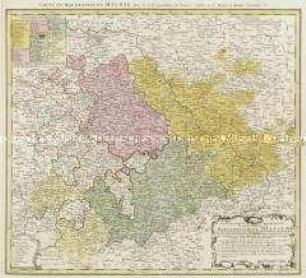
Geographische Abbildung des gantzen Umfangs der Marggrafschaft Meissen
Nova Comitatus Pappenheimensis Tabula : cumfinitimis diversorum Imperii statuum locis et tractibus, nec non Dynastia Bellenberg in Suevia sita
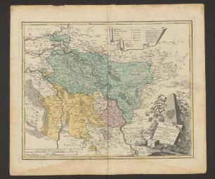
Charte vom Herzogthum Cleve : worauf zugleich das Fürstenthum Meurs nebst den Königl. Preussie. Antheil des Herzogthums Geldern zu sehen ist
Karte: Partie orientale de la Nouvelle France ou du Canada; Nürnberg 1755
Tabula Geographica Totam Borussiam ut et Districtum Notecensem. Mit einer Nebenkarte: Charte welche den Netz District vorstellet
Geographische Verzeichnung des Bvdissinischen Creises in dem Marggrafthum Ober Lavsitz
Atlas Regni Bohemiae: Repraesentatio Geographica Circuli Egerani, nec non Elnbogensis / Carte du Territoire d'Egra, & du Cercle d'Elnbogue
Tabula Geographica Campaniae. Mit zwei Nebenkarten: Reims und Troyes
Pläne der kanadischen Städte Louisburg, Québec und Halifax unter französischer und englischer Herrschaft
Stadtplan und Ansicht von Mannheim, ca. 1:15 000, Kupferst., um 1740 : Hodierna sedes Electoris Palatini Manheimium Ichno- et Scenographice novissime exhibitum / Prostat In Officina Homanniana. - Circa 1:15 000 [Nürnberg] : Officina Homanniana, [um 1740]. - 1 Karte : Kupferdruck, teilweise flächenkoloriert ; Bildgröße 48 x 57 cm, Blattgröße 55 x 64 cm // NO oben. - Windrose unten links. - Titelkartusche rechts Mitte. - Mit einer Ansicht unten unter Kartenbild:Prospect der Churf. Residenz St. Manheim
Stadtplan von Mailand. Beigefügt sind Grundrisse der Festungen Novara, Lodi, Tortona, Mortara, Valenza und Mantua in der österreichischen Lombardei.
Special Post Karte durch den Schwaebischen Kreis : in welcher die Poststations-Oerter, Strassen und Weiten Geographisch vorgestellt werden
Geographische Abbildung des gantzen Umfangs der Marggrafschaft Meissen
Nova Comitatus Pappenheimensis Tabula : cumfinitimis diversorum Imperii statuum locis et tractibus, nec non Dynastia Bellenberg in Suevia sita