Verzeichnung
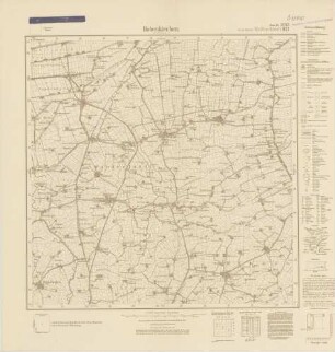
Topographische Karte Blatt 2313 Hohenkirchen Maßstab: 1:25.000 Herausgeber: Preußische Landesaufnahme/Niedersächsisches Landesvermessungsamt
- Reference number
-
NLA OL, K-ZE, Best. 298 Z Nr. 3272
- Further information
-
Identifikation: Band:
Index-Gruppe: Institution: Niedersächsisches Landesvermessungsamt
Index-Gruppe: Institution: Preußische Landesaufnahme
- Context
-
Zentraler Kartenbestand Oldenburg >> 5 Bezirksregierung Weser-Ems >> 5.7 Landkreis Friesland >> 5.7.3 Größere Gebietsteile >> 5.7.3.6 Gemeinde Wangerland
- Holding
-
NLA OL, K-ZE Zentraler Kartenbestand Oldenburg
- Indexentry place
-
Hohenkirchen, Gemeinde, Karte
- Date of creation
-
- 1951
- Other object pages
- Last update
-
16.06.2025, 11:08 AM CEST
Data provider
This object is provided by:
Niedersächsisches Landesarchiv. If you have any questions about the object, please contact the data provider.
Niedersächsisches Landesarchiv. If you have any questions about the object, please contact the data provider.
Object type
- Verzeichnung
Time of origin
- - 1951
Other Objects (12)

2313 Hohenkirchen i. Oldenburg
Blatt 2313 Hohenkirchen i. Oldenburg
Blatt 921 Hohenkirchen, neu: 2313 Hohenkirchen i. Oldenburg
Blatt 921 Hohenkirchen i. Oldenburg, neu: 2313
Blatt 921 Hohenkirchen i. Oldenburg, neu: 2313
Blatt 921 Hohenkirchen i. Oldenburg, neu: 2313

2313 (alte Nr.: 921) Hohenkirchen in Oldenburg
2313 (alte Nr.: 921) Hohenkirchen in Oldenburg, Meßtischblatt (4cm - Karte)
Bodenkundlich-geologische Karte der Marschengebiete (Bl. 2313 Hohenkirchen) Maßstab: 1:25.000 Bearbeiter: H. Voigt Herausgeber/Druck: Niedersächsisches Landesamt für Bodenforschung
Raumordnungskataster topografische Karte, 2313 Hohenkirchen (Oldb) mit Tettens, u.a. Flächennutzungsplan, Erdgas-HD-Leitung, Hauptwasserleitung Maßstab: 1:25.000 Hrsg.: Niedersächsisches Landesverwaltungsamt
2313
2313. Aken
2313 Hohenkirchen i. Oldenburg
Blatt 2313 Hohenkirchen i. Oldenburg
Blatt 921 Hohenkirchen, neu: 2313 Hohenkirchen i. Oldenburg
Blatt 921 Hohenkirchen i. Oldenburg, neu: 2313
Blatt 921 Hohenkirchen i. Oldenburg, neu: 2313
Blatt 921 Hohenkirchen i. Oldenburg, neu: 2313
2313 (alte Nr.: 921) Hohenkirchen in Oldenburg
2313 (alte Nr.: 921) Hohenkirchen in Oldenburg, Meßtischblatt (4cm - Karte)
Bodenkundlich-geologische Karte der Marschengebiete (Bl. 2313 Hohenkirchen) Maßstab: 1:25.000 Bearbeiter: H. Voigt Herausgeber/Druck: Niedersächsisches Landesamt für Bodenforschung
Raumordnungskataster topografische Karte, 2313 Hohenkirchen (Oldb) mit Tettens, u.a. Flächennutzungsplan, Erdgas-HD-Leitung, Hauptwasserleitung Maßstab: 1:25.000 Hrsg.: Niedersächsisches Landesverwaltungsamt
2313