Karte / Plan
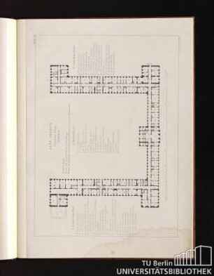
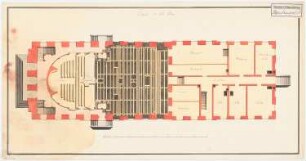
[Grundrisse des Schlosses zu Bonn. Keller und Grundmauern, Parterre, 2. Etage und Etage noble]. Plan du rez-de-chaussee.
- Archivaliensignatur
-
RW Karten, 3129 - b
- Maße
-
Höhe: 65, 85 x 49, 65 x 50 cm, Breite: 100
- Bemerkungen
-
VI 27/35
- Kontext
-
RW Karten >> 7. Baupläne >> 7.1. Schlösser und Gärten >> 7.1.1. Adlige und fürstliche Häuser
- Bestand
-
RW Karten
- Laufzeit
-
[Um 1777]
- Weitere Objektseiten
- Provenienz
-
Diverse Registraturbildner
- Geliefert über
- Letzte Aktualisierung
-
17.09.2025, 14:43 MESZ
Datenpartner
Dieses Objekt wird bereitgestellt von:
Landesarchiv Nordrhein-Westfalen. Abteilung Rheinland. Bei Fragen zum Objekt wenden Sie sich bitte an den Datenpartner.
Landesarchiv Nordrhein-Westfalen. Abteilung Rheinland. Bei Fragen zum Objekt wenden Sie sich bitte an den Datenpartner.
Objekttyp
- Karten / Pläne
Entstanden
- [Um 1777]
Ähnliche Objekte (12)
![[Grundrisse des Schlosses zu Bonn. Keller und Grundmauern, Parterre, 2. Etage und Etage noble]. Plan du rez-de-chaussee. Plan de l'etage noble.](https://iiif.deutsche-digitale-bibliothek.de/image/2/1efab531-e76f-4f7e-9c18-6c5bae91e223/full/!306,450/0/default.jpg)
[Grundrisse des Schlosses zu Bonn. Keller und Grundmauern, Parterre, 2. Etage und Etage noble]. Plan du rez-de-chaussee. Plan de l'etage noble.
![[Grundrisse des Schlosses zu Bonn. Keller und Grundmauern, Parterre, 2. Etage und Etage noble]. Plan du seconde etage.-Praes.](https://iiif.deutsche-digitale-bibliothek.de/image/2/af40dec9-ca90-46bf-b0e3-6301c68a916b/full/!306,450/0/default.jpg)
[Grundrisse des Schlosses zu Bonn. Keller und Grundmauern, Parterre, 2. Etage und Etage noble]. Plan du seconde etage.-Praes.
![[Grundrisse des Schlosses zu Bonn. Keller und Grundmauern, Parterre, 2. Etage und Etage noble]. Plan des caves et murs de fondation.](https://iiif.deutsche-digitale-bibliothek.de/image/2/367fadb0-71ed-4364-bd38-b4fbc8477d1d/full/!306,450/0/default.jpg)
[Grundrisse des Schlosses zu Bonn. Keller und Grundmauern, Parterre, 2. Etage und Etage noble]. Plan des caves et murs de fondation.

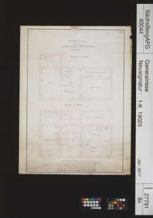
Grundriss Parterre und 1. Etage
Grundriss Parterre und 1. Etage
Blatt III. Alte Charité. Parterre Etage.
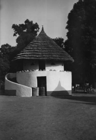
Case Malinké à étage. Rez - de - chausée: pi`ce à palabres Etage: habitation du chef
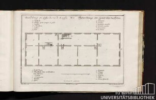
No. 5. Second Etage au dessus du rez de chausée. Andere Etage oder Grund über Erden.
Laboratorium der Bergakademie Freiberg; Parterre und 1. Etage
Bergamtsgebäude in Annaberg; Parterre, erste und zweite Etage
Königliches Schauspielhaus, Potsdam: Grundriss Parterre und 1. Etage

II. Etage ; I. Etage
[Grundrisse des Schlosses zu Bonn. Keller und Grundmauern, Parterre, 2. Etage und Etage noble]. Plan du rez-de-chaussee. Plan de l'etage noble.
[Grundrisse des Schlosses zu Bonn. Keller und Grundmauern, Parterre, 2. Etage und Etage noble]. Plan du seconde etage.-Praes.
[Grundrisse des Schlosses zu Bonn. Keller und Grundmauern, Parterre, 2. Etage und Etage noble]. Plan des caves et murs de fondation.
Grundriss Parterre und 1. Etage
Grundriss Parterre und 1. Etage
Blatt III. Alte Charité. Parterre Etage.
Case Malinké à étage. Rez - de - chausée: pi`ce à palabres Etage: habitation du chef
No. 5. Second Etage au dessus du rez de chausée. Andere Etage oder Grund über Erden.
Laboratorium der Bergakademie Freiberg; Parterre und 1. Etage
Bergamtsgebäude in Annaberg; Parterre, erste und zweite Etage
Königliches Schauspielhaus, Potsdam: Grundriss Parterre und 1. Etage