- Alternative title
-
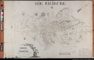
PLAN / von DÜNKIRCHEN / an der NORD=SEE, / nebst Charte
- Location
-
Deutsches Historisches Museum, Berlin
- Inventory number
-
Do 2006/376
- Measurements
-
Höhe x Breite: 48,5 x 36,3 cm (Blatt)
Höhe x Breite: 14,8 x 27,3 cm (Karte)
Höhe x Breite: 34,4 x 29,6 cm (Platte)
- Material/Technique
-
Druckfarbe, Papier, Kupferstich, koloriert
- Classification
-
Kartografie (Gattung)
- Subject (what)
-
Dünkirchen
- Event
-
Herstellung
- (who)
-
Stecher: Friedrich Müller
Verleger ?: I. B. Klein
- (where)
-
Leipzig [historisch: Leipzig], Deutschland [historisch: Heiliges Römisches Reich deutscher Nation]
- (when)
-
1793
- Rights
-
Deutsches Historisches Museum
- Last update
-
24.03.2023, 9:30 AM CET
Data provider
This object is provided by:
Stiftung Deutsches Historisches Museum. If you have any questions about the object, please contact the data provider.
Stiftung Deutsches Historisches Museum. If you have any questions about the object, please contact the data provider.
Object type
- Fortifikationsplan
Associated
- Stecher: Friedrich Müller
- Verleger ?: I. B. Klein
Time of origin
- 1793
Other Objects (12)

Plan der Herausgabe des Lokalblatts "Die schwäbische Eisenbahn" über das soziale Leben durch den Buchdrucker Friedrich Müller in Stuttgart
Zehntrechnungen 1855-1860 mit Beilagen
Zehntrechnungen 1861-1870 mit Beilagen

¬Die¬ gesundheitliche Bedeutung des Sonnenlichtes mit besonderer Berücksichtigung der Schulhygiene

¬Die¬ Lungenschwindsucht, deren Ursache und Verhütung mit besonderer Berücksichtigung der Schulgesundheitspflege
Pokal (versilbert, Höhe: 21,5cm) mit Gravur "Herrn Advokat-Anwalt F. Müller zur Erinnerung an den denkwürdigen politischen Prozeß des Jahres 1850, die freigesprochenen Angeklagten"
"Karte von dem entstehenden Forstreviere an der Maiburg im Forstbegange und Amte Fürstenau": zwischen Bippen und Kl. Bokern. Dazu Angaben über Dodenart, Bodengüte, Holzbestände mit Alter und Größe. Ausf.-Art: Farbige Zeichnung Herst.: Friedrich Müller, Förster Format: 48 x 146 cm Maßstab: 1 : 3200

"Karte von dem entstehenden Forstreviere an der Maiburg im Forstbegange und Amte Fürstenau": zwischen Bippen und Kl. Bokern. Dazu Angaben über Dodenart, Bodengüte, Holzbestände mit Alter und Größe. Registratursignatur: Forstinsp. Lingen, Rev. Bersenbrück = Bockern, Amt Fürstenau, III, Hptabt. Nr. 7, 16 b. Ausf.-Art: Farbige Zeichnung Herst.: Friedrich Müller, Förster Format: 48 x 146 cm Maßstab: 1 : 3200

"Karte von dem entstehenden Forstreviere an der Maiburg im Forstbegange und Amte Fürstenau": zwischen Bippen und Kl. Bokern. Dazu Angaben über Dodenart, Bodengüte, Holzbestände mit Alter und Größe. Registratursignatur: Forstinsp. Lingen, Rev. Bersenbrück = Bockern, Amt Fürstenau, III, Hptabt. Nr. 8, 16 a. Ausf.-Art: Farbige Zeichnung Herst.: Friedrich Müller, Förster Format: 48 x 146 cm Maßstab: 1 : 3200
Stellenbesetzung
Müller, Friedrich
Untersuchungen über die Cyclisierung von Tripeptiden
Plan der Herausgabe des Lokalblatts "Die schwäbische Eisenbahn" über das soziale Leben durch den Buchdrucker Friedrich Müller in Stuttgart
Zehntrechnungen 1855-1860 mit Beilagen
Zehntrechnungen 1861-1870 mit Beilagen
¬Die¬ gesundheitliche Bedeutung des Sonnenlichtes mit besonderer Berücksichtigung der Schulhygiene
¬Die¬ Lungenschwindsucht, deren Ursache und Verhütung mit besonderer Berücksichtigung der Schulgesundheitspflege
Pokal (versilbert, Höhe: 21,5cm) mit Gravur "Herrn Advokat-Anwalt F. Müller zur Erinnerung an den denkwürdigen politischen Prozeß des Jahres 1850, die freigesprochenen Angeklagten"
"Karte von dem entstehenden Forstreviere an der Maiburg im Forstbegange und Amte Fürstenau": zwischen Bippen und Kl. Bokern. Dazu Angaben über Dodenart, Bodengüte, Holzbestände mit Alter und Größe. Ausf.-Art: Farbige Zeichnung Herst.: Friedrich Müller, Förster Format: 48 x 146 cm Maßstab: 1 : 3200
"Karte von dem entstehenden Forstreviere an der Maiburg im Forstbegange und Amte Fürstenau": zwischen Bippen und Kl. Bokern. Dazu Angaben über Dodenart, Bodengüte, Holzbestände mit Alter und Größe. Registratursignatur: Forstinsp. Lingen, Rev. Bersenbrück = Bockern, Amt Fürstenau, III, Hptabt. Nr. 7, 16 b. Ausf.-Art: Farbige Zeichnung Herst.: Friedrich Müller, Förster Format: 48 x 146 cm Maßstab: 1 : 3200
"Karte von dem entstehenden Forstreviere an der Maiburg im Forstbegange und Amte Fürstenau": zwischen Bippen und Kl. Bokern. Dazu Angaben über Dodenart, Bodengüte, Holzbestände mit Alter und Größe. Registratursignatur: Forstinsp. Lingen, Rev. Bersenbrück = Bockern, Amt Fürstenau, III, Hptabt. Nr. 8, 16 a. Ausf.-Art: Farbige Zeichnung Herst.: Friedrich Müller, Förster Format: 48 x 146 cm Maßstab: 1 : 3200
Stellenbesetzung
Müller, Friedrich