Bilder
Reproduktionen von Plänen Gemeinde Hirschau
Inhalt: Hirschau Bodennutzungskarten 1849, 1950 und 1969 sowie Bodenwertkarte 1969
- Reference number
-
D 150/Dia 4785-4788
- Former reference number
-
prefix: D 150/Dia
- Material
-
Dia (Farbe)
- Context
-
D 150 Foto- und Bildsammlung >> Dias
- Holding
-
D 150 Foto- und Bildsammlung
- Indexbegriff subject
-
Bodennutzungskarte Hirschau
Bodenwertkarte Hirschau
- Indexentry place
-
Hirschau, Bodennutzungskarte
Hirschau, Bodenwertkarte
- Other object pages
- Last update
-
29.04.2025, 8:35 AM CEST
Data provider
This object is provided by:
Stadtarchiv Tübingen. If you have any questions about the object, please contact the data provider.
Stadtarchiv Tübingen. If you have any questions about the object, please contact the data provider.
Object type
- Bild / Fotografie
Other Objects (12)

Hirschau
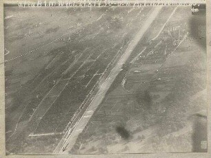
Luftaufnahmen von Hirschau
Fahrzeugflotte des Standorts Hirschau
Hirschau, Gesamtansicht mit Spitzberg, Luftbild
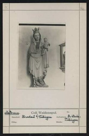
Madonna Standort: Hirschau bei Tübingen
Reproduktion Plan Altstadtsanierung Tübingen, Verkehrsplanung
Hirschau: Plan des kurfürstlichen Schlosses zu Hirschau
Reproduktion Plan Altstadtsanierung Tübingen, bestehender Verkehr
Hirschau: Madergasse 6 (Scheune), Obere Kelter, Friedhofkapelle
Isar nördlich München und Hirschau (1500 m)
Reproduktion Plan Altstadtsanierung Tübingen, Blockeinteilung, Sonderamt für Altstadtsanierung
Hirschau: Friedhofkapelle innen u. außen, Palmesel, Kirche innen u. außen
Hirschau
Luftaufnahmen von Hirschau
Fahrzeugflotte des Standorts Hirschau
Hirschau, Gesamtansicht mit Spitzberg, Luftbild
Madonna Standort: Hirschau bei Tübingen
Reproduktion Plan Altstadtsanierung Tübingen, Verkehrsplanung
Hirschau: Plan des kurfürstlichen Schlosses zu Hirschau
Reproduktion Plan Altstadtsanierung Tübingen, bestehender Verkehr
Hirschau: Madergasse 6 (Scheune), Obere Kelter, Friedhofkapelle
Isar nördlich München und Hirschau (1500 m)
Reproduktion Plan Altstadtsanierung Tübingen, Blockeinteilung, Sonderamt für Altstadtsanierung