Karte / Plan
Niederlande topographische Karte Blatt 3 Scheldemündung, Maastricht und friesische Inseln 1925 1 : 200 000 50 x 113 farb. Druck B Nr. 157
- Former reference number
-
B 157
- Further information
-
Ort: Niederlande Niederlande
- Context
-
Karten A (Allgemein) >> 1. Topographische Karte, Übersichtskarten >> 1.1. Geographische, topographische Karten
- Holding
-
W 051 Karten A (Allgemein)
- Indexentry place
-
Niederlande Niederlande
Friesische Inseln, topographische Karte s. Niederlande, 1925
Maastricht, topographische Karte s. Niederlande, 1925
Niederlande, topographische Karte, 1925
Scheldemündung, topographische Karte s. Niederlande, 1925
- Date of creation
-
1925
- Other object pages
- Provenance
-
Sammlungsregistraturbildner
- Delivered via
- Last update
-
05.11.2025, 4:07 PM CET
Data provider
This object is provided by:
Landesarchiv Nordrhein-Westfalen. Abteilung Westfalen. If you have any questions about the object, please contact the data provider.
Landesarchiv Nordrhein-Westfalen. Abteilung Westfalen. If you have any questions about the object, please contact the data provider.
Object type
- Karten / Pläne
Time of origin
- 1925
Other Objects (12)

Friesische Sprache und friesische Bewegung
Das friesische Pfund und die friesische Mark

Friesische Dorfstraße
Friesische Bauernstube.
Friesische Märchen

Friesische Funde
Friesische Schlösser

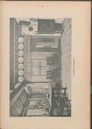
Friesische Stube
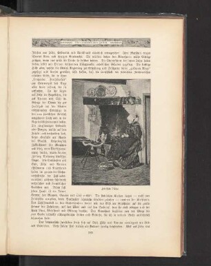
Friesische Küche.
Friesische Kirchen
Friesische Schiffe
Friesische Weihnachtsgeschichte
Friesische Sprache und friesische Bewegung
Das friesische Pfund und die friesische Mark
Friesische Dorfstraße
Friesische Bauernstube.
Friesische Märchen
Friesische Funde
Friesische Schlösser
Friesische Stube
Friesische Küche.
Friesische Kirchen
Friesische Schiffe
Friesische Weihnachtsgeschichte
Friesische Sprache und friesische Bewegung
Das friesische Pfund und die friesische Mark
Friesische Dorfstraße
Friesische Bauernstube.
Friesische Märchen
Friesische Funde
Friesische Schlösser
Friesische Stube
Friesische Küche.
Friesische Kirchen
Friesische Schiffe