Karten und Pläne
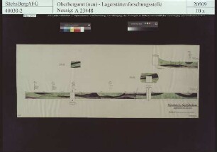
St. Christoph bei Breitenbrunn, 1. westliches Überhauen, 14m - 137m
- Reference number
-
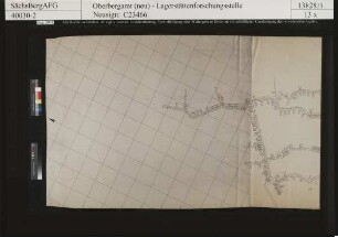
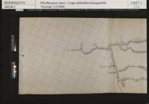
Sächsisches Staatsarchiv, 40030 Staatliche Lagerstättenforschungsstelle, Nr. 2-C23460 (Zu benutzen im Bergarchiv Freiberg)
- Further information
-
Kartentype: Profil
Maßstab: 1 : 50
Format: 100 x 97
- Context
-
40030 Staatliche Lagerstättenforschungsstelle >> 2. Risse >> 2.1. Erze >> 2.1.03. Sachsen >> 2.1.03.17. S >> 2.1.03.17.02. St. Christoph bei Breitenbrunn
- Holding
-
40030 Staatliche Lagerstättenforschungsstelle
- Date of creation
-
ohne Datum
- Other object pages
- View digital item at providers-website
- Rights
-
Es gilt die Sächsische Archivbenutzungsverordnung vom 8. September 2022 (SächsGVBl. S. 526).
- Last update
-
21.03.2024, 8:16 AM CET
Data provider
This object is provided by:
Sächsisches Staatsarchiv. If you have any questions about the object, please contact the data provider.
Sächsisches Staatsarchiv. If you have any questions about the object, please contact the data provider.
Object type
- Karten und Pläne
Time of origin
- ohne Datum
Other Objects (12)

St. Christoph bei Breitenbrunn, III. östliches Überhauen, westlicher Stoß
St. Christoph bei Breitenbrunn, Flur Breitenbrunn
St. Christoph bei Breitenbrunn, 1. Streichstrecke im 1. westlichen Überhauen
St. Christoph bei Breitenbrunn, Flur Breitenbrunn, Vertikalintensität
St. Christoph bei Breitenbrunn, Flur Breitenbrunn, Horizontalintensität

St. Christoph bei Breitenbrunn
St. Christoph bei Breitenbrunn
St. Christoph bei Breitenbrunn
St. Christoph bei Breitenbrunn
St. Christoph bei Breitenbrunn
St. Christoph bei Breitenbrunn
St. Christoph bei Breitenbrunn, St. Christoph Stolln
St. Christoph bei Breitenbrunn, III. östliches Überhauen, westlicher Stoß
St. Christoph bei Breitenbrunn, Flur Breitenbrunn
St. Christoph bei Breitenbrunn, 1. Streichstrecke im 1. westlichen Überhauen
St. Christoph bei Breitenbrunn, Flur Breitenbrunn, Vertikalintensität
St. Christoph bei Breitenbrunn, Flur Breitenbrunn, Horizontalintensität
St. Christoph bei Breitenbrunn
St. Christoph bei Breitenbrunn
St. Christoph bei Breitenbrunn
St. Christoph bei Breitenbrunn
St. Christoph bei Breitenbrunn
St. Christoph bei Breitenbrunn