Archivale
Unterer Havelwasserstraße km neu 74,1 - 75,1; km alt 91,5 - 92,4 linkes Ufer
- Reference number
-
57 WSD K 5251 A
- Context
-
Rep. 57 Wasserstraßendirektion Potsdam - Karten >> Wasserstraßenamt Genthin >> Vermessungs- und Kartenwesen >> Untere Havel mit Plauer See
- Holding
-
57 WSD K (15603) Rep. 57 Wasserstraßendirektion Potsdam - Karten
- Date of creation
-
1894-1927
- Other object pages
- Last update
-
07.04.2025, 11:31 AM CEST
Data provider
This object is provided by:
Brandenburgisches Landeshauptarchiv. If you have any questions about the object, please contact the data provider.
Brandenburgisches Landeshauptarchiv. If you have any questions about the object, please contact the data provider.
Object type
- Archivale
Time of origin
- 1894-1927
Other Objects (12)

Unterer Havelwasserstraße km neu 74,1 - 75,1; km alt 91,5 - 92,4 rechtes Ufer
Unterer Havelwasserstraße km neu 75,1 - 75,8; km alt 90,8 - 91,5
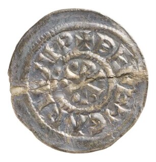
Münze, Denar, 915/924
Güterplan der Gemarkungen Muggensturm und Ötigheim Streckenausschnitt: 91,5 bis 92,4 km
Atmos KM 751
Obere Havelwasserstraße km 0 bis km 60,7
Untere Havelwasserstraße. Km 115,1 - Km 117,4
Untere Havelwasserstraße, Km 137 - 163
Untere Havelwasserstraße. Untere Havel Km 50,8 - Km 52,3
Untere Havelwasserstraße. Untere Havel Km 132,1 - Km 134,3
Untere Havelwasserstraße. Untere Havel Km 58,0 - Km 60,2
Untere Havelwasserstraße. Untere Havel Km 19,7 - Km 21,9
Unterer Havelwasserstraße km neu 74,1 - 75,1; km alt 91,5 - 92,4 rechtes Ufer
Unterer Havelwasserstraße km neu 75,1 - 75,8; km alt 90,8 - 91,5
Münze, Denar, 915/924
Güterplan der Gemarkungen Muggensturm und Ötigheim Streckenausschnitt: 91,5 bis 92,4 km
Atmos KM 751
Obere Havelwasserstraße km 0 bis km 60,7
Untere Havelwasserstraße. Km 115,1 - Km 117,4
Untere Havelwasserstraße, Km 137 - 163
Untere Havelwasserstraße. Untere Havel Km 50,8 - Km 52,3
Untere Havelwasserstraße. Untere Havel Km 132,1 - Km 134,3
Untere Havelwasserstraße. Untere Havel Km 58,0 - Km 60,2