
- Reference number
-
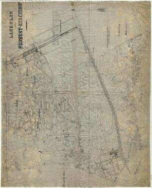
ELAB 104/800
- Former reference number
-
Vor-/Altsignatur: Schrank 2 - Fach 1, Plan 16a
- Further information
-
Maßstab: 1:1000
Beschreibung: 1 Kopie
- Context
-
Plansammlung Friedhöfe >> 104.1. Pläne Friedhof Stahnsdorf (Süd-West-Kirchhof) >> 104.1.11 Topographische Pläne
- Holding
-
ELAB 104 Plansammlung Friedhöfe
- Indexentry place
-
Südwestkirchhof Stahnsdorf
- Date of creation
-
Keine Angabe
- Other object pages
- Provenance
-
Friedhofsverwaltung Stahnsdorf
- Zugangsbeschränkungen
-
Schutzfrist: Keine (0 Jahre)
- Last update
-
06.03.2025, 6:37 PM CET
Data provider
This object is provided by:
Evangelisches Landeskirchliches Archiv in Berlin. If you have any questions about the object, please contact the data provider.
Evangelisches Landeskirchliches Archiv in Berlin. If you have any questions about the object, please contact the data provider.
Object type
- Plan
Time of origin
- Keine Angabe
Other Objects (12)
Lageplan Südwestkirchhof auf Topografischer Karte
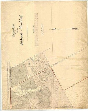
Lageplan Südwestkirchhof auf Topografischer Karte

Topografische Karte - Detailplan 3 Südwestkirchhof Stahnsdorf
Topografische Karte - Detailplan 2 Südwestkirchhof Stahnsdorf
Topografische Karte - Detailplan 1 Südwestkirchhof Stahnsdorf
Topografische Karte - Planunterlagen über den Südwestkirchhof Blatt 9
Topografische Karte - Planunterlagen über den Südwestkirchhof Blatt 2

Topografische Karte - Planunterlagen über den Südwestkirchhof Blatt 11
Topografische Karte - Planunterlagen über den Südwestkirchhof Blatt 7
Topografische Karte - Planunterlagen über den Südwestkirchhof Blatt 6
Topografische Karte - Planunterlagen über den Südwestkirchhof Blatt 10
Topografische Karte - Planunterlagen über den Südwestkirchhof Blatt 4
Lageplan Südwestkirchhof auf Topografischer Karte
Lageplan Südwestkirchhof auf Topografischer Karte
Topografische Karte - Detailplan 3 Südwestkirchhof Stahnsdorf
Topografische Karte - Detailplan 2 Südwestkirchhof Stahnsdorf
Topografische Karte - Detailplan 1 Südwestkirchhof Stahnsdorf
Topografische Karte - Planunterlagen über den Südwestkirchhof Blatt 9
Topografische Karte - Planunterlagen über den Südwestkirchhof Blatt 2
Topografische Karte - Planunterlagen über den Südwestkirchhof Blatt 11
Topografische Karte - Planunterlagen über den Südwestkirchhof Blatt 7
Topografische Karte - Planunterlagen über den Südwestkirchhof Blatt 6
Topografische Karte - Planunterlagen über den Südwestkirchhof Blatt 10