- Alternative title
-
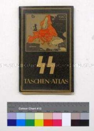
Soldatenatlas
- Location
-
Deutsches Historisches Museum, Berlin
- Inventory number
-
Do 77/281II
- Measurements
-
Höhe x Breite: 24 x 34 cm
- Material/Technique
-
Papier, gedruckt
- Classification
-
Kartografie (Gattung)
- Subject (what)
-
Geographie
Wehrmacht (Deutschland)
Militär
- Event
-
Herstellung
- (who)
-
Herausgeber: Oberkommando der Wehrmacht, Abt. Inland
- (where)
-
Deutschland [historisch: Deutsches Reich]
- (when)
-
1941
- Rights
-
Deutsches Historisches Museum
- Last update
-
24.03.2023, 9:30 AM CET
Data provider
This object is provided by:
Stiftung Deutsches Historisches Museum. If you have any questions about the object, please contact the data provider.
Stiftung Deutsches Historisches Museum. If you have any questions about the object, please contact the data provider.
Object type
- Atlas
Associated
- Herausgeber: Oberkommando der Wehrmacht, Abt. Inland
Time of origin
- 1941
Other Objects (12)
Taschenatlas für SS-Angehörige mit geografischen und historischen Karten

АТЛАС МИРА (Atlas Mira)

Atlas
Atlas

O-Atlas II : atlas techniki ortodontycznej
Velʾký atlas sveta : atlas pre celú rodinu
O-Atlas II : Atlas der kieferorthopädischen Technik
O-Atlas II : atlas of orthodontic techniques
O-Atlas II : atlas des techniques orthodontiques
Mond-Atlas
Atlas Schulterarthroskopie
Atlas Koloproktologie
Taschenatlas für SS-Angehörige mit geografischen und historischen Karten
АТЛАС МИРА (Atlas Mira)
Atlas
Atlas
O-Atlas II : atlas techniki ortodontycznej
Velʾký atlas sveta : atlas pre celú rodinu
O-Atlas II : Atlas der kieferorthopädischen Technik
O-Atlas II : atlas of orthodontic techniques
O-Atlas II : atlas des techniques orthodontiques
Mond-Atlas
Atlas Schulterarthroskopie