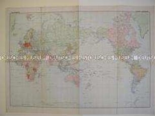
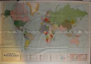
Politisch-administrative Karte
Politisch-administrative Weltkarte mit den ehemaligen deutschen Kolonien
- Alternative title
-
Gea-Weltkarte
- Location
-
Deutsches Historisches Museum, Berlin
- Inventory number
-
Do 60/712
- Measurements
-
Höhe x Breite: 61,8 x 87 cm
- Material/Technique
-
Papier, gedruckt
- Classification
-
Kartografie (Gattung)
- Subject (what)
-
Kolonialismus
- Event
-
Herstellung
- (who)
-
Verlag: Gea Verlag Albers K.G.
- (where)
-
Berlin, Deutschland [historisch: Deutsches Reich]
- (when)
-
um 1940
- Rights
-
Deutsches Historisches Museum
- Last update
-
24.03.2023, 9:30 AM CET
Data provider
This object is provided by:
Stiftung Deutsches Historisches Museum. If you have any questions about the object, please contact the data provider.
Stiftung Deutsches Historisches Museum. If you have any questions about the object, please contact the data provider.
Object type
- Politisch-administrative Karte
Associated
- Verlag: Gea Verlag Albers K.G.
Time of origin
- um 1940
Other Objects (12)

Politisch-administrative Weltkarte
Weltkarte mit den ehemaligen deutschen Kolonialgebieten
Politisch-administrative Weltkarte aus der Zeit des 2. Weltkrieges

Weltkarte

Weltkarte
Weltkarte
Weltkarte
Weltkarte

Weltkarte.

Weltkarte
Weltkarte
Weltkarte.
Politisch-administrative Weltkarte
Weltkarte mit den ehemaligen deutschen Kolonialgebieten
Politisch-administrative Weltkarte aus der Zeit des 2. Weltkrieges
Weltkarte
Weltkarte
Weltkarte
Weltkarte
Weltkarte
Weltkarte.
Weltkarte
Weltkarte
Weltkarte.
Politisch-administrative Weltkarte
Weltkarte mit den ehemaligen deutschen Kolonialgebieten
Politisch-administrative Weltkarte aus der Zeit des 2. Weltkrieges
Weltkarte
Weltkarte
Weltkarte
Weltkarte
Weltkarte
Weltkarte.
Weltkarte
Weltkarte