- Reference number
-
W 051, 47742
- Dimensions
-
Höhe: 29 cm, Breite: 42 cm, Maßstab: in Ruthen
- Notes
-
siehe auch Kartensammlung A 4913
- Further information
-
Ort: Lippe
- Context
-
Karten A (Allgemein) >> 3. Gewässer >> 3.1. Gewässer / Wasserbau >> 3.1.3. Lippe
- Holding
-
W 051 Karten A (Allgemein)
- Indexentry place
-
Lippe
- Date of creation
-
1766
- Other object pages
- Provenance
-
Sammlungsregistraturbildner
- Delivered via
- Last update
-
17.09.2025, 3:10 PM CEST
Data provider
This object is provided by:
Landesarchiv Nordrhein-Westfalen. Abteilung Westfalen. If you have any questions about the object, please contact the data provider.
Landesarchiv Nordrhein-Westfalen. Abteilung Westfalen. If you have any questions about the object, please contact the data provider.
Object type
- Karten / Pläne
Time of origin
- 1766
Other Objects (12)

Lippe: 1. Theil der Lipp Carte von Wesel bis Hamm

Lippe Flußlauf von Wesel bis Hamm Wesel bis zur Lippe-Insel bei Gartrop Zweyter Theil der Lipp Carte von Wesel bis Hamm .... 1766 200 rh. Ruten = 23,1 cm 66 x 400 kol. Zeichnung v. Schöler; U. Caemmerer; A. W. Thelen KSM IV Nr. 24

Lippe Flußlauf von Wesel bis Hamm Lippe-Insel bei Gartrop bis Dorsten Zweyter Theil der Lipp Carte von Wesel bis Hamm ... 1766 200 rh. Ruten = 23 cm 67 x 394 kol. Zeichnung A. W. Thelen; v. Schöler; U. Caemmerer KSM IV Nr. 23

Lippe Flußlauf von Wesel bis Hamm Hamm bis Haus Rauschenburg Vierter Theil der Lipp Carte von Wesel bis Hamm... 1766 200 rh. Ruten = 22 cm 64 x 396 kol. Zeichnung v. Schöler; U. Caemmerer; A. W. Thelen KSM IV Nr. 27

Lippe Flußlauf von Wesel bis Hamm Haus Rauschenburg bis Krempingsbach Fünffter Theil der Lipp Carte von Wesel bis Hamm... 1766 200 rh. Ruten = 22 cm 64 x 287 kol. Zeichnung v. Schöler; U. Caemmerer; A. W. Thelen KSM IV Nr. 28

Lippe Flußlauf von Wesel bis Hamm Werne, Siechenhaus bis Werne, Mühle Siebenter Theil der Lipp Carte von Wesel bis Hamm.... 1766 200 rh. Ruten = 22 cm 59 x 84 kol. Zeichnung v. Schöler; U. Caemmerer; A. W. Thelen KSM IV Nr. 29

Lippe Flußlauf von Wesel bis Hamm Von der Werneschen Mühle bis Hamm Achter Theil der Lipp Carte von Wesel bis Hamm .... 1766 200 rh. Ruten = 23,6 cm 60,5 x 397 kol. Zeichnung v. Schöler, Kapitän; U. Caemmerer, Leutnant; A. W. Thelen, Hauptmann KSM IV Nr. 30

Lippe Flußlauf von Wesel bis Hamm Dorsten bis Haltern Dritter Theil (der Lipp Carte von Wesel bis Hamm)... 1766 (200 rh. Ruten = 22 cm) 64 x 528 kol. Zeichnung v. Schöler; U. Caemmerer; A. W. Thelen Bem.: Kartentitel stark beschädigt KSM IV Nr. 26

Lippe Flußlauf von Wesel bis Hamm Lippe-Insel bei Gartrop bis Dorsten Erster Theil der Lipp Carte von Wesel bis Hamm zu der ... niedergesetzten Commission wegen Schiffbarmachung der Lippe, welche von Wesel aus dem Rhein bis an die Lipp Insul Nr. 65 gehet .... 1766 200 rh. Ruten = 23,1 cm 66 x 406 kol. Zeichnung v. Schöler; U. Caemmerer; A. W. Thelen KSM IV Nr. 25
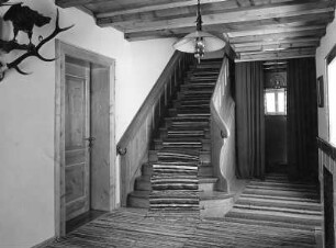
Haus Lipp : Haus Lipp. Treppenhaus

Lipp
Verlegung der klevischen Poststrecke Hamm-Lünen-Haltern-Wesel nach Unna-Bochum-Dinslaken-Wesel
Lippe: 1. Theil der Lipp Carte von Wesel bis Hamm
Lippe Flußlauf von Wesel bis Hamm Wesel bis zur Lippe-Insel bei Gartrop Zweyter Theil der Lipp Carte von Wesel bis Hamm .... 1766 200 rh. Ruten = 23,1 cm 66 x 400 kol. Zeichnung v. Schöler; U. Caemmerer; A. W. Thelen KSM IV Nr. 24
Lippe Flußlauf von Wesel bis Hamm Lippe-Insel bei Gartrop bis Dorsten Zweyter Theil der Lipp Carte von Wesel bis Hamm ... 1766 200 rh. Ruten = 23 cm 67 x 394 kol. Zeichnung A. W. Thelen; v. Schöler; U. Caemmerer KSM IV Nr. 23
Lippe Flußlauf von Wesel bis Hamm Hamm bis Haus Rauschenburg Vierter Theil der Lipp Carte von Wesel bis Hamm... 1766 200 rh. Ruten = 22 cm 64 x 396 kol. Zeichnung v. Schöler; U. Caemmerer; A. W. Thelen KSM IV Nr. 27
Lippe Flußlauf von Wesel bis Hamm Haus Rauschenburg bis Krempingsbach Fünffter Theil der Lipp Carte von Wesel bis Hamm... 1766 200 rh. Ruten = 22 cm 64 x 287 kol. Zeichnung v. Schöler; U. Caemmerer; A. W. Thelen KSM IV Nr. 28
Lippe Flußlauf von Wesel bis Hamm Werne, Siechenhaus bis Werne, Mühle Siebenter Theil der Lipp Carte von Wesel bis Hamm.... 1766 200 rh. Ruten = 22 cm 59 x 84 kol. Zeichnung v. Schöler; U. Caemmerer; A. W. Thelen KSM IV Nr. 29
Lippe Flußlauf von Wesel bis Hamm Von der Werneschen Mühle bis Hamm Achter Theil der Lipp Carte von Wesel bis Hamm .... 1766 200 rh. Ruten = 23,6 cm 60,5 x 397 kol. Zeichnung v. Schöler, Kapitän; U. Caemmerer, Leutnant; A. W. Thelen, Hauptmann KSM IV Nr. 30
Lippe Flußlauf von Wesel bis Hamm Dorsten bis Haltern Dritter Theil (der Lipp Carte von Wesel bis Hamm)... 1766 (200 rh. Ruten = 22 cm) 64 x 528 kol. Zeichnung v. Schöler; U. Caemmerer; A. W. Thelen Bem.: Kartentitel stark beschädigt KSM IV Nr. 26
Lippe Flußlauf von Wesel bis Hamm Lippe-Insel bei Gartrop bis Dorsten Erster Theil der Lipp Carte von Wesel bis Hamm zu der ... niedergesetzten Commission wegen Schiffbarmachung der Lippe, welche von Wesel aus dem Rhein bis an die Lipp Insul Nr. 65 gehet .... 1766 200 rh. Ruten = 23,1 cm 66 x 406 kol. Zeichnung v. Schöler; U. Caemmerer; A. W. Thelen KSM IV Nr. 25
Haus Lipp : Haus Lipp. Treppenhaus
Lipp