- Alternative title
-
1. Karte: PLAN. / Von der Gegend bey / Berlin / Auf welchen das Mannoeuvre
- Location
-
Deutsches Historisches Museum, Berlin
- Inventory number
-
Do 2006/ 1. 1-3
- Measurements
-
Höhe x Breite: 55,5 x 45 cm
- Material/Technique
-
Papier, gezeichnet, koloriert, handgeschrieben
- Classification
-
Kartografie (Gattung)
- Subject (what)
-
Manöver
- Event
-
Herstellung
- (when)
-
zwischen 21.05.1785 und 23.05.1785
- Rights
-
Deutsches Historisches Museum
- Last update
-
24.03.2023, 9:27 AM CET
Data provider
This object is provided by:
Stiftung Deutsches Historisches Museum. If you have any questions about the object, please contact the data provider.
Stiftung Deutsches Historisches Museum. If you have any questions about the object, please contact the data provider.
Object type
- Manöverplan
Time of origin
- zwischen 21.05.1785 und 23.05.1785
Other Objects (12)

Stadtplan Berlin-Tempelhof-Schöneberg_3. ergänzte Auflage
Stadtplan Tempelhof (Tempelhof)
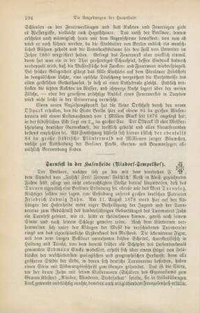
Turnfest in der Hasenheide (Rixdorf-Tempelhof)
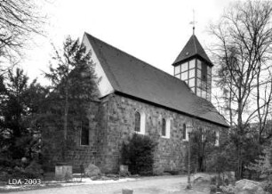
Dorfkirche Tempelhof; Berlin, Tempelhof-Schöneberg
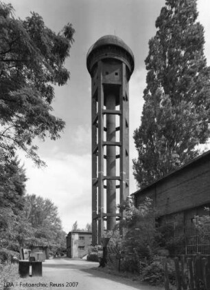
Bahnbetriebswerk Tempelhof; Berlin, Tempelhof-Schöneberg
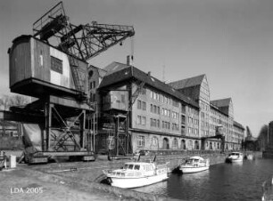
Hafen Tempelhof; Berlin, Tempelhof-Schöneberg
Stadtplan von Berlin. Verwaltungsbezirk Tempelhof
Stadtplan von Berlin. Verwaltungsbezirk Tempelhof
Stadtplan von Berlin. Verwaltungsbezirk Tempelhof
Stadtplan von Berlin. Verwaltungsbezirk Tempelhof
Stadtplan von Berlin. Verwaltungsbezirk Tempelhof
Stadtplan von Berlin. Verwaltungsbezirk Tempelhof
Stadtplan Berlin-Tempelhof-Schöneberg_3. ergänzte Auflage
Stadtplan Tempelhof (Tempelhof)
Turnfest in der Hasenheide (Rixdorf-Tempelhof)
Dorfkirche Tempelhof; Berlin, Tempelhof-Schöneberg
Bahnbetriebswerk Tempelhof; Berlin, Tempelhof-Schöneberg
Hafen Tempelhof; Berlin, Tempelhof-Schöneberg
Stadtplan von Berlin. Verwaltungsbezirk Tempelhof
Stadtplan von Berlin. Verwaltungsbezirk Tempelhof
Stadtplan von Berlin. Verwaltungsbezirk Tempelhof
Stadtplan von Berlin. Verwaltungsbezirk Tempelhof
Stadtplan von Berlin. Verwaltungsbezirk Tempelhof