- Alternative title
-
Die große Englandkarte
- Location
-
Deutsches Historisches Museum, Berlin
- Inventory number
-
Do 70/510II
- Measurements
-
Höhe x Breite: 86 x 61 cm
- Material/Technique
-
Papier, gedruckt
- Classification
-
Kartografie (Gattung)
- Subject (what)
-
Weltkrieg, 2.
- Event
-
Herstellung
- (who)
-
Verlag: Carl Lange Verlag
- (where)
-
Duisburg, Deutschland [historisch: Deutsches Reich]
- (when)
-
1941
- Rights
-
Deutsches Historisches Museum
- Last update
-
24.03.2023, 9:28 AM CET
Data provider
This object is provided by:
Stiftung Deutsches Historisches Museum. If you have any questions about the object, please contact the data provider.
Stiftung Deutsches Historisches Museum. If you have any questions about the object, please contact the data provider.
Object type
- Militär-strategische Karte
Associated
- Verlag: Carl Lange Verlag
Time of origin
- 1941
Other Objects (12)

Militär-strategische Karte von Groß-Britannien
Militär-strategische Karte des Pazifik-Raumes
Militär-strategische Karte zum Krieg in Afrika
Militär-strategische Karte zum Krieg im Pazifik
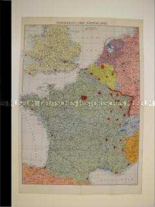
Militär-strategische Karte von Frankreich und England
Militär-strategische Karte von Krakau und Umgebung (Fliegerkarte)
Militär-strategische Wandkarte mit den Befestigungsanlagen in Frankreich
Militär-strategische Karte von der Westfront zum Kriegsbeginn 1914
Militär-strategische Karte des Mittelmeerraumes mit den Flottenstützpunkten der Kriegsgegner
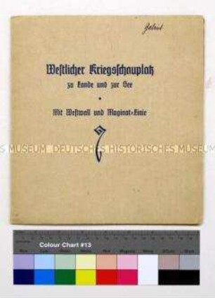
Militär-strategische Karte von westlichen Kriegsschauplatz mit Westwall und Maginot-Linie
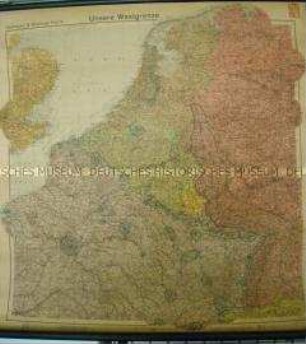
Militär-strategische Karte mit den Verteidigungsanlagen an der deutsch-französischen Grenze
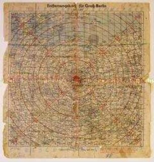
Militär-strategische Karte zur Kennzeichnung der Entfernungen von und bis Berlin
Militär-strategische Karte von Groß-Britannien
Militär-strategische Karte des Pazifik-Raumes
Militär-strategische Karte zum Krieg in Afrika
Militär-strategische Karte zum Krieg im Pazifik
Militär-strategische Karte von Frankreich und England
Militär-strategische Karte von Krakau und Umgebung (Fliegerkarte)
Militär-strategische Wandkarte mit den Befestigungsanlagen in Frankreich
Militär-strategische Karte von der Westfront zum Kriegsbeginn 1914
Militär-strategische Karte des Mittelmeerraumes mit den Flottenstützpunkten der Kriegsgegner
Militär-strategische Karte von westlichen Kriegsschauplatz mit Westwall und Maginot-Linie
Militär-strategische Karte mit den Verteidigungsanlagen an der deutsch-französischen Grenze