Archivale
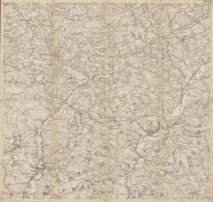
Preußische Kartenaufnahme - Uraufnahme - Band X, Blatt 6 (heutige Topographische Karte 5009 Overath mit Honrath)Maßstab 1:25000
Ausführung: Neudruck des Landesvermessungsamtes NRW 1993
Verfasser: Mauve, Lieutenant im 5. Infantriereg.
- Reference number
-
K, 0013
- Context
-
Karten und Pläne >> 5.5. Honrath
- Holding
-
Karten und Pläne
- Date of creation
-
1845
- Other object pages
- Delivered via
- Last update
-
17.09.2025, 3:42 PM CEST
Data provider
This object is provided by:
Stadtarchiv Lohmar. If you have any questions about the object, please contact the data provider.
Stadtarchiv Lohmar. If you have any questions about the object, please contact the data provider.
Object type
- Archivale
Time of origin
- 1845
Other Objects (12)

Preußische Kartenaufnahme - Uraufnahme (5009 Overath)
Preußische Kartenaufnahme - Uraufnahme (5009 Overath)
5009 Overath
5009 Overath
5009 Overath
Overath (5009)
Kartenaufnahme der Rheinlande unter v. Müffling 1824-1825 (5009 Overath)
Kartenaufnahme der Rheinlande unter v. Müffling 1824-1825 (5009 Overath)
Blatt 5009 Overath
Waldfunktionskarte 5009 Overath
Topographische Karte Overath (mit Honrath) Nr. 2910 (heutige Nr. 5009)Maßstab 1:25000
Biotopkataster /LINFOS 5009 Overath
Preußische Kartenaufnahme - Uraufnahme (5009 Overath)
Preußische Kartenaufnahme - Uraufnahme (5009 Overath)
5009 Overath
5009 Overath
5009 Overath
Overath (5009)
Kartenaufnahme der Rheinlande unter v. Müffling 1824-1825 (5009 Overath)
Kartenaufnahme der Rheinlande unter v. Müffling 1824-1825 (5009 Overath)
Blatt 5009 Overath
Waldfunktionskarte 5009 Overath
Topographische Karte Overath (mit Honrath) Nr. 2910 (heutige Nr. 5009)Maßstab 1:25000