- Alternative title
-
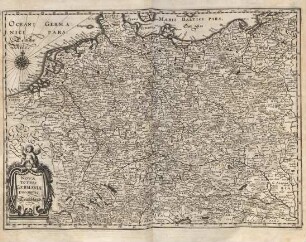
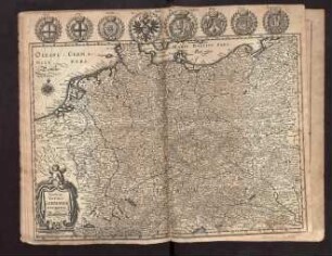
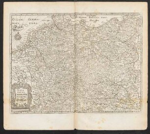
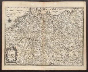
NOVA TOTIVS GERMANIAE DESCRIPTIO.
- Location
-
Deutsches Historisches Museum, Berlin
- Inventory number
-
Do 54/1665
- Measurements
-
Höhe x Breite: 44,2 x 54,5 cm (Blatt)
Höhe x Breite: 39,2 x 49,5 cm (Platte)
Höhe x Breite: 33,5 x 46,8 cm (Karte)
- Material/Technique
-
Papier, Kupferstich, koloriert
- Classification
-
Kartografie (Gattung)
- Subject (what)
-
Deutschland
Mitteleuropa
- Event
-
Herstellung
- (who)
-
Kartograf, Drucker, Verleger: Willem Janszoon Blaeu
- (where)
-
Amsterdam, Niederlande
- (when)
-
um 1635
- Rights
-
Deutsches Historisches Museum
- Last update
-
24.03.2023, 9:30 AM CET
Data provider
This object is provided by:
Stiftung Deutsches Historisches Museum. If you have any questions about the object, please contact the data provider.
Stiftung Deutsches Historisches Museum. If you have any questions about the object, please contact the data provider.
Object type
- Politische Karte
Associated
- Kartograf, Drucker, Verleger: Willem Janszoon Blaeu
Time of origin
- um 1635
Other Objects (12)
Nova totius Germaniae descriptio.

NOVA TOTIUS GERMANIAE DESCRIPTIO

Nova totius Germaniae Descriptio (Nachdruck)

Nova totius Germaniae descriptio. Teutschland.

Nova Totius Germaniae Descriptio (Faksimile)

Nova Totius Germaniae Descriptio Teutschland
Nova totius Germaniae descriptio. Deutschland.

Nova totius Germaniae descriptio Teuschland.
Nova Totius Germaniae Descriptio Teutschland.

Nova Germaniae Descriptio
Nova Germaniae Descriptio
Nova Totius Germaniae
Nova totius Germaniae descriptio.
NOVA TOTIUS GERMANIAE DESCRIPTIO
Nova totius Germaniae Descriptio (Nachdruck)
Nova totius Germaniae descriptio. Teutschland.
Nova Totius Germaniae Descriptio (Faksimile)
Nova Totius Germaniae Descriptio Teutschland
Nova totius Germaniae descriptio. Deutschland.
Nova totius Germaniae descriptio Teuschland.
Nova Totius Germaniae Descriptio Teutschland.
Nova Germaniae Descriptio
Nova Germaniae Descriptio