Karte / Plan
Bestimmung des Hochwasserfreigebiets der Ruhr. Querprofile km 49,8 - 55,9. 8 Bl.
- Archivaliensignatur
-
RW Karten, 4591 - c
- Maße
-
Höhe: 70 cm / 74 cm, Breite: 52 cm / 58 cm, Maßstab: 1 : 1250 (L), 1 : 100 (H)
- Kontext
-
RW Karten >> 5. Gewässer >> 5.3. Ruhr >> 5.3.3. Hochwasserfreigebiete
- Bestand
-
RW Karten
- Laufzeit
-
[um 1900]
- Weitere Objektseiten
- Provenienz
-
Diverse Registraturbildner
- Geliefert über
- Letzte Aktualisierung
-
05.11.2025, 15:42 MEZ
Datenpartner
Dieses Objekt wird bereitgestellt von:
Landesarchiv Nordrhein-Westfalen. Abteilung Rheinland. Bei Fragen zum Objekt wenden Sie sich bitte an den Datenpartner.
Landesarchiv Nordrhein-Westfalen. Abteilung Rheinland. Bei Fragen zum Objekt wenden Sie sich bitte an den Datenpartner.
Objekttyp
- Karten / Pläne
Entstanden
- [um 1900]
Ähnliche Objekte (12)

Bestimmung des Hochwasserfreigebiets der Ruhr. Querprofile km 49,8 - 55,9. 8 Bl.

Bestimmung des Hochwasserfreigebiets der Ruhr. Querprofile km 49,8 - 55,9. 8 Bl.

Bestimmung des Hochwasserfreigebiets der Ruhr. Querprofile km 49,8 - 55,9. 8 Bl.

Bestimmung des Hochwasserfreigebiets der Ruhr. Querprofile km 49,8 - 55,9. 8 Bl.

Bestimmung des Hochwasserfreigebiets der Ruhr. Querprofile km 49,8 - 55,9. 8 Bl.

Bestimmung des Hochwasserfreigebiets der Ruhr. Querprofile km 49,8 - 55,9. 8 Bl.

Bestimmung des Hochwasserfreigebiets der Ruhr. Querprofile km 49,8 - 55,9. 8 Bl.
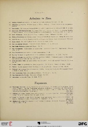
Fayencen (Nr. 498-559)

Querprofile zum Überschwemmungsgebiet der Ruhr
Querprofile der Ruhr (Mitte 19 Jhdt.)
Messungen der Ruhr (Geschwindigkeit, Wassermenge, Querprofile)
559, Wagen No 559.
Bestimmung des Hochwasserfreigebiets der Ruhr. Querprofile km 49,8 - 55,9. 8 Bl.
Bestimmung des Hochwasserfreigebiets der Ruhr. Querprofile km 49,8 - 55,9. 8 Bl.
Bestimmung des Hochwasserfreigebiets der Ruhr. Querprofile km 49,8 - 55,9. 8 Bl.
Bestimmung des Hochwasserfreigebiets der Ruhr. Querprofile km 49,8 - 55,9. 8 Bl.
Bestimmung des Hochwasserfreigebiets der Ruhr. Querprofile km 49,8 - 55,9. 8 Bl.
Bestimmung des Hochwasserfreigebiets der Ruhr. Querprofile km 49,8 - 55,9. 8 Bl.
Bestimmung des Hochwasserfreigebiets der Ruhr. Querprofile km 49,8 - 55,9. 8 Bl.
Fayencen (Nr. 498-559)
Querprofile zum Überschwemmungsgebiet der Ruhr
Querprofile der Ruhr (Mitte 19 Jhdt.)
Messungen der Ruhr (Geschwindigkeit, Wassermenge, Querprofile)