- Alternativer Titel
-
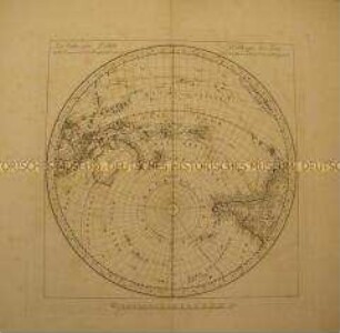
Die Obere oder Nordliche Halbkugel der Erde / auf den Horizont von Berlin stereographisch entworfen von J. E. Bode Astronom der Königl. Pr. Acad. d. Wissensch 1783
- Standort
-
Deutsches Historisches Museum, Berlin
- Inventarnummer
-
Do 54/199
- Maße
-
Höhe x Breite: 67,5 x 64,7 cm, Höhe x Breite: 48,9 x 46,8 cm (Platte), Höhe x Breite: 44,5 x 43,3 cm (Grafik) (Blatt)
- Material/Technik
-
Blatt: Tinte (schwarz), Papier, Kupferstich
- Klassifikation
-
Kartografie (Gattung)
- Bezug (was)
-
Weltkarte
Nördliche Hemisphäre
- Ereignis
-
Herstellung
- (wer)
-
Astronom: Johann Elert Bode
Stecher: Carl F. Gürsch
Königlich Preußische Akademie der Wissenschaaften
- (wo)
-
Berlin, Deutschland [historisch: Preußen, Königreich]
- (wann)
-
1783
- Rechteinformation
-
Deutsches Historisches Museum
- Letzte Aktualisierung
-
24.03.2023, 09:29 MEZ
Datenpartner
Dieses Objekt wird bereitgestellt von:
Stiftung Deutsches Historisches Museum. Bei Fragen zum Objekt wenden Sie sich bitte an den Datenpartner.
Stiftung Deutsches Historisches Museum. Bei Fragen zum Objekt wenden Sie sich bitte an den Datenpartner.
Objekttyp
- Weltkarte
Beteiligte
- Astronom: Johann Elert Bode
- Stecher: Carl F. Gürsch
- Königlich Preußische Akademie der Wissenschaaften
Entstanden
- 1783
Ähnliche Objekte (12)
Die südliche Halbkugel der Erde

Die Untere oder Südliche Halbkugel der Erde : auf den Horizont von Berlin stereographisch entworfen

Die Obere oder Nordliche Halbkugel der Erde : auf den Horizont von Berlin stereographisch entworfen

Tafeln für den Lauf des Uranus

Aus einem Schreiben des Prof. Bode : Berlin, den 15ten May 1798

Astronomisches Jahrbuch für das Jahr 1811. nebst einer Sammlung der neuesten in die astronomischen Wissenschaften einschlagenden Abhandlungen, Beobachtungen und Nachrichten / Mit Genehmhaltung der Königl. Akademie der Wissenschaften berechnet und herausgegeben von J. E. Bode, Astronom und Mitglied der Akademie. - Berlin : Verf. ; Braunes, 1808
![Aus einem Schreiben des Prof. Bode : Berlin, den 12. Oct[ober] 1799](https://iiif.deutsche-digitale-bibliothek.de/image/2/256c087b-76bd-4955-9fb4-46fee174757b/full/!306,450/0/default.jpg)
Aus einem Schreiben des Prof. Bode : Berlin, den 12. Oct[ober] 1799

Astronomisches Jahrbuch für das Jahr 1816. nebst einer Sammlung der neuesten in die astronomischen Wissenschaften einschlagenden Abhandlungen, Beobachtungen und Nachrichten / Mit Genehmhaltung der Königl. Akademie der Wissenschaften berechnet und herausgegeben von J. E. Bode, Königl. Astronom und Mitglied der Akademie. - Berlin : Verf. ; Hitzig, 1813

Astronomisches Jahrbuch für das Jahr 1818. nebst einer Sammlung der neuesten in die astronomischen Wissenschaften einschlagenden Abhandlungen, Beobachtungen und Nachrichten / von J. E. Bode. - Berlin, 1815

Berlin, bey dem Verfasser und in Commission bey Lange: Astronomisches Jahrbuch für das Jahr 1804; nebst einer Sammlung der neuesten in die astronomischen Wissenschaften einschlagenden Abhandlungen, Beobachtungen und Nachrichten. Herausgegeben von J. S. Rode, etc. Mit 2 Kupf. 268 S. 1801. --- Dasselbe auf das J. 1805.

Berlin, in d. Himburgschen Buchhandl.: Johann Elert Bode von dem neuen zwischen Mars und Jupiter entdeckten achten Hauptplaneten des Sonnensystems. 136 S. nebst einer Kupfertafel. 8. 1802.

Neuer Himmels-Atlas, im größten Format / von J. E. Bode, Astronomen und Mitglied der Königl. Academie der Wissenschaften in Berlin. - Berlin. - Drittes heft von vier Blättern, 1799
Die südliche Halbkugel der Erde
Die Untere oder Südliche Halbkugel der Erde : auf den Horizont von Berlin stereographisch entworfen
Die Obere oder Nordliche Halbkugel der Erde : auf den Horizont von Berlin stereographisch entworfen
Tafeln für den Lauf des Uranus
Aus einem Schreiben des Prof. Bode : Berlin, den 15ten May 1798
Astronomisches Jahrbuch für das Jahr 1811. nebst einer Sammlung der neuesten in die astronomischen Wissenschaften einschlagenden Abhandlungen, Beobachtungen und Nachrichten / Mit Genehmhaltung der Königl. Akademie der Wissenschaften berechnet und herausgegeben von J. E. Bode, Astronom und Mitglied der Akademie. - Berlin : Verf. ; Braunes, 1808
Aus einem Schreiben des Prof. Bode : Berlin, den 12. Oct[ober] 1799
Astronomisches Jahrbuch für das Jahr 1816. nebst einer Sammlung der neuesten in die astronomischen Wissenschaften einschlagenden Abhandlungen, Beobachtungen und Nachrichten / Mit Genehmhaltung der Königl. Akademie der Wissenschaften berechnet und herausgegeben von J. E. Bode, Königl. Astronom und Mitglied der Akademie. - Berlin : Verf. ; Hitzig, 1813
Astronomisches Jahrbuch für das Jahr 1818. nebst einer Sammlung der neuesten in die astronomischen Wissenschaften einschlagenden Abhandlungen, Beobachtungen und Nachrichten / von J. E. Bode. - Berlin, 1815
Berlin, bey dem Verfasser und in Commission bey Lange: Astronomisches Jahrbuch für das Jahr 1804; nebst einer Sammlung der neuesten in die astronomischen Wissenschaften einschlagenden Abhandlungen, Beobachtungen und Nachrichten. Herausgegeben von J. S. Rode, etc. Mit 2 Kupf. 268 S. 1801. --- Dasselbe auf das J. 1805.
Berlin, in d. Himburgschen Buchhandl.: Johann Elert Bode von dem neuen zwischen Mars und Jupiter entdeckten achten Hauptplaneten des Sonnensystems. 136 S. nebst einer Kupfertafel. 8. 1802.