- Alternative title
-
A. NEWE / MAPE OF / GERMANY / Newly Augmented by
- Location
-
Deutsches Historisches Museum, Berlin
- Inventory number
-
1990/1058
- Measurements
-
Höhe x Breite: 35 x 45 cm (Karte)
Höhe x Breite: 44,8 x 60,4 cm (Blatt)
Höhe x Breite: 40,8 x 52,9 cm (Platte)
- Material/Technique
-
Druckfarbe, Papier, Kupferstich, koloriert
- Classification
-
Kartografie (Gattung)
- Subject (what)
-
Mitteleuropa
Deutschland
- Event
-
Herstellung
- (who)
-
Verleger: Roger Rea (d. Ältere)
Kartograf: John Speed
- (where)
-
London, Großbritannien und Nordirland [historisch: England]
- (when)
-
1626
- Rights
-
Deutsches Historisches Museum
- Last update
-
24.03.2023, 9:28 AM CET
Data provider
This object is provided by:
Stiftung Deutsches Historisches Museum. If you have any questions about the object, please contact the data provider.
Stiftung Deutsches Historisches Museum. If you have any questions about the object, please contact the data provider.
Object type
- Politische Karte
Associated
- Verleger: Roger Rea (d. Ältere)
- Kartograf: John Speed
Time of origin
- 1626
Other Objects (12)
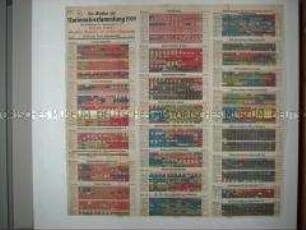
Tafel mit den Ergebnissen der Wahl zur Nationalversammlung

Carte D'Allemagne Divisée d'apres le traité de Paix Fait à Vienne le 20 Novembre 1815. Ou se trouvent le Royaume de Prusse, L'Empire D'Autriche, la Conféderation Germanique les Royme. des Pays-Bas, de Hanovre, de Bavière, de Wurtemberg et de Lombard-Venitien

Politische Karte des Deutschen Reiches mit Ortsverzeichnis

Karte des Deutschen Reiches mit der Einteilung der Wahlkreise für die Wahl der Nationalversammlung 1919

Karte der Sowjetunion mit den Lebensstationen Lenins, herausgegeben anlässlich seines 100. Geburtstages
Karte der in der Tschecho-Slowakei ansässigen Nationalitäten
Karte aus der "Berliner Morgenpost" zum "Anschluss" Österreichs
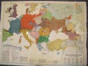
Politisch-ethnografische Karte von Europa
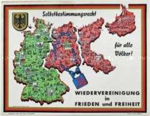
Schematische Karte mit der Forderung nach der Wiederherstellung Deutschlands in den Grenzen von 1937 (BRD, DDR, Westpreußen, Ostpreußen) mit rückseitigen Text
Politische Karte von Deutschland mit den Ergebnissen der Wahl zur Nationalversammlung 1919

Politische Karte Deutschlands mit den Ergebnissen der Reichstagswahl am 7. Dezember 1924
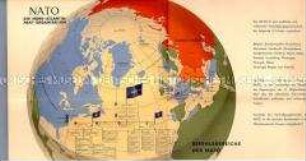
Politische Karte zum Befehlsbereich der NATO
Tafel mit den Ergebnissen der Wahl zur Nationalversammlung
Carte D'Allemagne Divisée d'apres le traité de Paix Fait à Vienne le 20 Novembre 1815. Ou se trouvent le Royaume de Prusse, L'Empire D'Autriche, la Conféderation Germanique les Royme. des Pays-Bas, de Hanovre, de Bavière, de Wurtemberg et de Lombard-Venitien
Politische Karte des Deutschen Reiches mit Ortsverzeichnis
Karte des Deutschen Reiches mit der Einteilung der Wahlkreise für die Wahl der Nationalversammlung 1919
Karte der Sowjetunion mit den Lebensstationen Lenins, herausgegeben anlässlich seines 100. Geburtstages
Karte der in der Tschecho-Slowakei ansässigen Nationalitäten
Karte aus der "Berliner Morgenpost" zum "Anschluss" Österreichs
Politisch-ethnografische Karte von Europa
Schematische Karte mit der Forderung nach der Wiederherstellung Deutschlands in den Grenzen von 1937 (BRD, DDR, Westpreußen, Ostpreußen) mit rückseitigen Text
Politische Karte von Deutschland mit den Ergebnissen der Wahl zur Nationalversammlung 1919
Politische Karte Deutschlands mit den Ergebnissen der Reichstagswahl am 7. Dezember 1924