Karten und Pläne
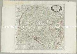
Cercle de Souabe, dans lequel sont distingnés les principaux Etats et les Enclaves de la maison d'Autriche
- Reference number
-
D 30/K 2764
- Former reference number
-
prefix: D 30/K
- Dimensions
-
46,5 x 50,5 cm
- Formal description
-
N: Helmstatt / S: Zürich - St. Gallen / W: Breisach / O: Landsberg
- Material
-
Papier
- Further information
-
Ausführung: Kupferstich, koloriert
Maßstab: 1:190000 20 geogr. Meilen = 7,8 cm
Druck / Verlag: Robert, Geograph ord. du Roy
- Context
-
D 30 Karten- und Plansammlung >> Landkarten >> Südwestdeutschland
- Holding
-
D 30 Karten- und Plansammlung
- Indexbegriff subject
-
#N/A
- Indexentry place
-
Schwaben
- Date of creation
-
1751
- Other object pages
- Last update
-
29.04.2025, 8:35 AM CEST
Data provider
This object is provided by:
Stadtarchiv Tübingen. If you have any questions about the object, please contact the data provider.
Stadtarchiv Tübingen. If you have any questions about the object, please contact the data provider.
Object type
- Karte und Plan
Time of origin
- 1751
Other Objects (12)

Cercle de Souabe, dans lequel sont distingués les principaux Etats, et les Enclaves de la Maison d'Autriche
Cercle de Souabe

Cercle de Souabe

Le Cercle de Souabe
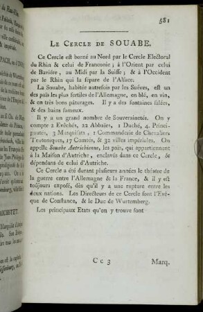
Le Cercle De Souabe.

La Souabe ou sont les Estats et Souverainetés Ecclesiastiques, Laiques et Villes Imperiales qui composent le cercle de Souabe et plusieurs Estats du Cercle et á la Maison d'Autriche Situés dans la Souabe

Le Cercle De Souabe : subdivisé en tous les Estats qui le composent

Le Cercle De Souabe : subdivisé en tous les Estats qui le composent

Le Cercle De Souabe subdivisé en tous les Estats qui le composent

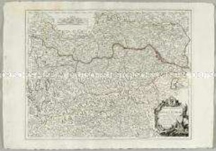
Le Cercle D'Autriche.
Partie Septentrionale du Cercle d'Autriche
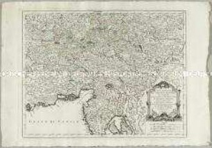
Partie Méridionale du Cercle d'Autriche
Cercle de Souabe, dans lequel sont distingués les principaux Etats, et les Enclaves de la Maison d'Autriche
Cercle de Souabe
Cercle de Souabe
Le Cercle de Souabe
Le Cercle De Souabe.
La Souabe ou sont les Estats et Souverainetés Ecclesiastiques, Laiques et Villes Imperiales qui composent le cercle de Souabe et plusieurs Estats du Cercle et á la Maison d'Autriche Situés dans la Souabe
Le Cercle De Souabe : subdivisé en tous les Estats qui le composent
Le Cercle De Souabe : subdivisé en tous les Estats qui le composent
Le Cercle De Souabe subdivisé en tous les Estats qui le composent
Le Cercle D'Autriche.
Partie Septentrionale du Cercle d'Autriche