Karte / Plan
Drenthe (Niederlande) Nieuwe Kaart van Drenthe 1769 Gradeinteilung 23 x 34 Nachdruck: T. Crajenschot, Amsterdam I. van Jagen
- Reference number
-
W 051, 21238
- Further information
-
Ort: Niederlande Drenthe
- Context
-
Karten A (Allgemein) >> 1. Topographische Karte, Übersichtskarten >> 1.2. Übersichtskarten >> 1.2.2. einzelne Orte
- Holding
-
W 051 Karten A (Allgemein)
- Indexentry place
-
Niederlande Drenthe
Drenthe, Übersicht, 1769
- Date of creation
-
1769
- Other object pages
- Provenance
-
Sammlungsregistraturbildner
- Delivered via
- Last update
-
05.11.2025, 3:50 PM CET
Data provider
This object is provided by:
Landesarchiv Nordrhein-Westfalen. Abteilung Westfalen. If you have any questions about the object, please contact the data provider.
Landesarchiv Nordrhein-Westfalen. Abteilung Westfalen. If you have any questions about the object, please contact the data provider.
Object type
- Karten / Pläne
Time of origin
- 1769
Other Objects (12)
Drenthe.

Overzigt der kerkelijke Geschiedenis van Drenthe

Drenthe (Niederlande) Territorialkarte Nieuwe Kaart van het vrye landschap Drenthe (1795) 1926 2 dt. Meilen = 3,3, cm 27,5 x 33 Nachdruck: van Gorcum & Co, Assen J. van Jagen B Nr. 328 l

Winterlandschaft in Drenthe

Bijdragen tot de geschiedenis en oudheden van Drenthe
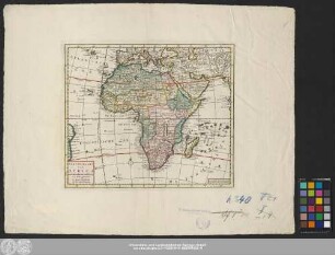
Nieuwe Kaart Van Africa

De 19 Penningen De Graven van Bentheim, buren van Drenthe
Noordelijke Hypotheekbank (Bank), Zorgvlied (Drenthe)

3: Urnen-Vondsten in Drenthe

Gezigt by Cowerden in Drenthe
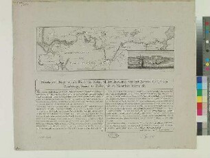
Nieuwe Kaart van het Canaal van Rendsburg
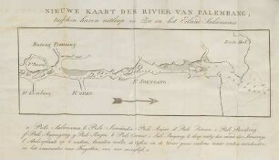
Nieuwe kaart der Rivier van Palembang
Drenthe.
Overzigt der kerkelijke Geschiedenis van Drenthe
Drenthe (Niederlande) Territorialkarte Nieuwe Kaart van het vrye landschap Drenthe (1795) 1926 2 dt. Meilen = 3,3, cm 27,5 x 33 Nachdruck: van Gorcum & Co, Assen J. van Jagen B Nr. 328 l
Winterlandschaft in Drenthe
Bijdragen tot de geschiedenis en oudheden van Drenthe
Nieuwe Kaart Van Africa
De 19 Penningen De Graven van Bentheim, buren van Drenthe
Noordelijke Hypotheekbank (Bank), Zorgvlied (Drenthe)
3: Urnen-Vondsten in Drenthe
Gezigt by Cowerden in Drenthe
Nieuwe Kaart van het Canaal van Rendsburg