Band
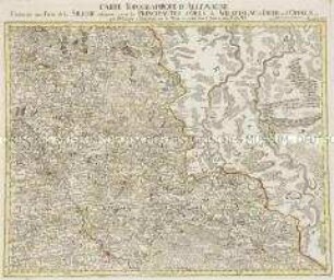
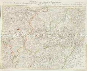
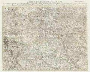
Feuille XXXVI: Carte Topographique D'Allemagne Contenant une Partie de la Silesie inferieure savoir les Principautes d'Oels, de Wratislau de Iauer et d'Oppeln

- Location
-
Universitäts- und Landesbibliothek Sachsen-Anhalt -- Altkt D II 2 [1] 4
- Extent
-
1 Karte; 46 x 60 cm, Kupferstich
- Language
-
Französisch
- Notes
-
Maßstab in grafischer Form (Lieux d'Allemagne)
Kopftitel. - Maßstab oben rechts auf dem Kartenrand
"avec P.d.S.M.I."
par I.W. Iaeger
Altkarte
- Bibliographic citation
-
La Silesie en 8. Feuilles
- Contributor
- Published
-
À Francfort sur le Mein : se vend chez l'Auteur , 1789
- Sponsorship
-
Die Digitalisierung wurde gefördert durch die Deutsche Digitale Bibliothek aus Mitteln des Programms „Neustart Kultur“ der Beauftragten der Bundesregierung für Kultur und Medien.
- DOI
-
doi:10.25673/59622
- URN
-
urn:nbn:de:gbv:3:3-1192015415-242478883-17
- Last update
-
03.06.2025, 7:50 AM CEST
Data provider
This object is provided by:
Martin-Luther-Universität Halle-Wittenberg, Universitäts- und Landesbibliothek Sachsen-Anhalt. If you have any questions about the object, please contact the data provider.
Martin-Luther-Universität Halle-Wittenberg, Universitäts- und Landesbibliothek Sachsen-Anhalt. If you have any questions about the object, please contact the data provider.
Object type
- Band
Associated
Time of origin
- À Francfort sur le Mein : se vend chez l'Auteur , 1789
Other Objects (12)
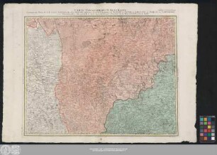
Grand Atlas . Bl. 36 (Niederschlesien...): Contenant une Partie de la Silesie inferieure savoir les Principautes d'Oels de Wratislau de Iauer et d'Oppeln et et
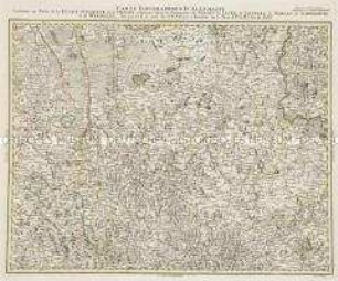
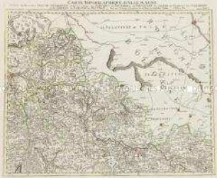
Feuille XXXV: Carte Topographique D'Allemagne Contenant une Partie de la Lusace Superieur, de la Silesie inferieure, savoir les Principautes de Glogau, de Iauer, de Liegnitz, de Wohlau, de Schweidnitz, et de Wradislau
Grand Atlas . Bl. 35 (Oberlausitz, Schlesien...): Contenant une Partie de la Lusace Superieur, de la Silesie inferieure, savoir les Principautes de Glogau, de Iauer, de Liegnitz, de Wohlau, de Schweidnitz, de Wradislau et et
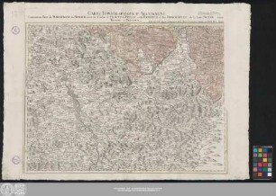
Feuille LIV: Carte Topographique D'Allemagne Contenant une Partie du Margraviat de Moravie, savoir les Cercles d'Olmutz de Prerau et de Hradisch et les Principautés de la haute Silesie savoir Tropau et Teschen
Grand Atlas . Bl. 54 (Mähren, Niederschlesien : Contenant une Partie du Margraviat de Moravie, savoir les Cercles d'Olmutz de Prerau et de Hradisch et les Principautés de la haute Silesie savoir Tropau et Teschen et et

Abrégé es Droits de Sa Majesté le Roi de Prusse sur plusieurs Principautés & Seigneuries en Silésie
Abrégé des Droits de Sa Majesté le Roi de Prusse sur Plusieurs Principautés & Seigneuries en Silesie
Abrégé des Droits de Sa Majesté le Roi de Prusse sur plusieurs Principautés & Seigneuries en Silesie
Grand Atlas . Bl. 26 (Niederschlesien): Contenant une Partie de la Silesie Inferieure, savoir les Cercles de Schwibus de Grunberg de Freystadt de Sagan de Glogau de Sternberg et de Guhrau le Baronie de Beuthen et et

Druckschrift "EXPOSITION FIDELÉ, DE LA MAISON ROYALE DE PRUSSE, ET ELECTORALE DE BRANDEBOURG, Sur plusieurs Principautés Duchés, & Seigneuries DE LA SILESIE."
Grand Atlas . Bl. 45 (Schlesien): Contenant la haute Silesie savoir les Principautés d'Oppeln, Ratibor, Troppau et Iaegerndorf, les Seigneuries de Plesen et de Beuten et une Partie du Margraviat de Moravie
Feuille XXVI: Carte Topographique D'Allemagne Contenant une Partie de la Silesie Inferieure savoir les Cercles de Schwibus de Grunberg de Freystadt de Sagan, de Glogau de Sternberg et de Guhrau le Baronie de Beuthen A. P. de s. M I.
Grand Atlas . Bl. 36 (Niederschlesien...): Contenant une Partie de la Silesie inferieure savoir les Principautes d'Oels de Wratislau de Iauer et d'Oppeln et et
Feuille XXXV: Carte Topographique D'Allemagne Contenant une Partie de la Lusace Superieur, de la Silesie inferieure, savoir les Principautes de Glogau, de Iauer, de Liegnitz, de Wohlau, de Schweidnitz, et de Wradislau
Grand Atlas . Bl. 35 (Oberlausitz, Schlesien...): Contenant une Partie de la Lusace Superieur, de la Silesie inferieure, savoir les Principautes de Glogau, de Iauer, de Liegnitz, de Wohlau, de Schweidnitz, de Wradislau et et
Feuille LIV: Carte Topographique D'Allemagne Contenant une Partie du Margraviat de Moravie, savoir les Cercles d'Olmutz de Prerau et de Hradisch et les Principautés de la haute Silesie savoir Tropau et Teschen
Grand Atlas . Bl. 54 (Mähren, Niederschlesien : Contenant une Partie du Margraviat de Moravie, savoir les Cercles d'Olmutz de Prerau et de Hradisch et les Principautés de la haute Silesie savoir Tropau et Teschen et et
Abrégé es Droits de Sa Majesté le Roi de Prusse sur plusieurs Principautés & Seigneuries en Silésie
Abrégé des Droits de Sa Majesté le Roi de Prusse sur Plusieurs Principautés & Seigneuries en Silesie
Abrégé des Droits de Sa Majesté le Roi de Prusse sur plusieurs Principautés & Seigneuries en Silesie
Grand Atlas . Bl. 26 (Niederschlesien): Contenant une Partie de la Silesie Inferieure, savoir les Cercles de Schwibus de Grunberg de Freystadt de Sagan de Glogau de Sternberg et de Guhrau le Baronie de Beuthen et et
Druckschrift "EXPOSITION FIDELÉ, DE LA MAISON ROYALE DE PRUSSE, ET ELECTORALE DE BRANDEBOURG, Sur plusieurs Principautés Duchés, & Seigneuries DE LA SILESIE."
Grand Atlas . Bl. 45 (Schlesien): Contenant la haute Silesie savoir les Principautés d'Oppeln, Ratibor, Troppau et Iaegerndorf, les Seigneuries de Plesen et de Beuten et une Partie du Margraviat de Moravie