Karte / Plan
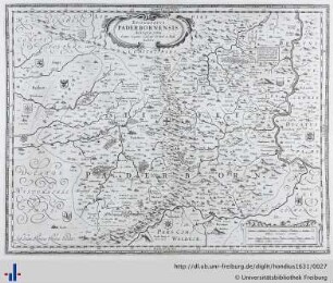
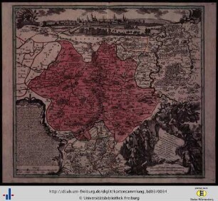
Paderborn (Bistum) Territorialkarte Paderbornensis episcopatus descriptio nova um 1640 3 dt. Meilen = 9,9 cm 35 x 46,5 Stich: Wilhelm Blaeuw, Amsterdam Johannes Gigas
- Reference number
-
W 051, 11961
- Further information
-
Ort: Fürstbistum Paderborn
- Context
-
Karten A (Allgemein) >> 1. Topographische Karte, Übersichtskarten >> 1.3. Territorialkarten
- Holding
-
W 051 Karten A (Allgemein)
- Indexentry place
-
Fürstbistum Paderborn
Paderborn, Bistum, Territorialkarte, 1640
- Date of creation
-
1640
- Other object pages
- Provenance
-
Sammlungsregistraturbildner
- Delivered via
- Last update
-
17.09.2025, 2:53 PM CEST
Data provider
This object is provided by:
Landesarchiv Nordrhein-Westfalen. Abteilung Westfalen. If you have any questions about the object, please contact the data provider.
Landesarchiv Nordrhein-Westfalen. Abteilung Westfalen. If you have any questions about the object, please contact the data provider.
Object type
- Karten / Pläne
Time of origin
- 1640
Other Objects (12)
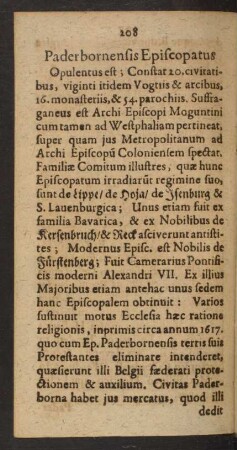
Paderbornensis Episcopatus
Paderbornensis Episcopatus.

Paderborn (Bistum) Territorialkarte Paderbornensis episcopatus descriptio nova 1.H. 17.Jh. 3 dt. Meilen = 10 cm 35 x 46,5 Stich: Jodocus Hondius, Amsterdam Johannes Gigas, Lügde B Nr. 360
Episcopatus Paderbornensis descriptio nova

Bistum Paderborn. " ...EPISCOPATUS PADERBORNENSIS ..."
Episcopatus Paderbornensis descriptio nova
Recens et accurata designatio episcopatus Paderbornensis

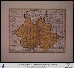
Paderborn (Bistum) Territorialkarte Paderbornensis episcopatus descriptio nova 1.H. 17.Jh. 3 dt. Meilen = 7,6 cm 27,5 x 36 Stich: Jodocus Hondius, Amsterdam Johannes Gigas, Lügde B Nr. 360a

Paderborn (Bistum) Territorialkarte Episcopatus Paderbornensis descriptio nova um 1700 3 dt. Meilen = 9,6 cm 35 x 45,5 farb. Stich: Peter Schenk und Gerard Valk, Amsterdam Johannes Gigas

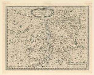
Paderborn (Fürstbistum) Territorialkarte Paderbornensis episcopatus descriptio nova auch Fürstabtei Corvey und die Ämter Schwalenberg-Oldenburg 1620 5 Wegstunden = 8,4 cm 34 x 45 farb. Nachdruck: Lügde 1992 Johannes Gigas
Episcopatus Paderbornensis descriptio nova. Mit Darstellung der Wappen der Territorien

Paderborn (Fürstbistum) Territorialkarte (Diocesis Paderbornensis) (1672) 17 x 25 Foto (aus Monumenta Paderbornensis des Ferdinand von Fürstenberg) Landsberg-Velen Nr. 506a
Paderbornensis Episcopatus
Paderbornensis Episcopatus.
Paderborn (Bistum) Territorialkarte Paderbornensis episcopatus descriptio nova 1.H. 17.Jh. 3 dt. Meilen = 10 cm 35 x 46,5 Stich: Jodocus Hondius, Amsterdam Johannes Gigas, Lügde B Nr. 360
Episcopatus Paderbornensis descriptio nova
Bistum Paderborn. " ...EPISCOPATUS PADERBORNENSIS ..."
Episcopatus Paderbornensis descriptio nova
Recens et accurata designatio episcopatus Paderbornensis
Paderborn (Bistum) Territorialkarte Paderbornensis episcopatus descriptio nova 1.H. 17.Jh. 3 dt. Meilen = 7,6 cm 27,5 x 36 Stich: Jodocus Hondius, Amsterdam Johannes Gigas, Lügde B Nr. 360a
Paderborn (Bistum) Territorialkarte Episcopatus Paderbornensis descriptio nova um 1700 3 dt. Meilen = 9,6 cm 35 x 45,5 farb. Stich: Peter Schenk und Gerard Valk, Amsterdam Johannes Gigas
Paderborn (Fürstbistum) Territorialkarte Paderbornensis episcopatus descriptio nova auch Fürstabtei Corvey und die Ämter Schwalenberg-Oldenburg 1620 5 Wegstunden = 8,4 cm 34 x 45 farb. Nachdruck: Lügde 1992 Johannes Gigas
Episcopatus Paderbornensis descriptio nova. Mit Darstellung der Wappen der Territorien