- Alternative title
-
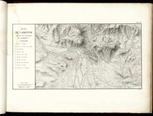
PLAN / DE GIRONNE / ET DE SES ENVIRONS
- Location
-
Deutsches Historisches Museum, Berlin
- Inventory number
-
Do 2006/1286.10
- Measurements
-
Höhe x Breite: 44 x 58,5 cm (Blatt)
Höhe x Breite: 26 x 41,5 cm (Karte)
Höhe x Breite: 30 x 55 cm (Platte)
- Material/Technique
-
Karte: Papier, Kupferstich, teilkoloriert
- Classification
-
Kartografie (Gattung)
- Subject (what)
-
Katalonien
Spanien
- Event
-
Herstellung
- (who)
-
Stecher: Alexandre Blondeau
- (where)
-
Paris, Frankreich
- (when)
-
1821
- Rights
-
Deutsches Historisches Museum
- Last update
-
24.03.2023, 9:30 AM CET
Data provider
This object is provided by:
Stiftung Deutsches Historisches Museum. If you have any questions about the object, please contact the data provider.
Stiftung Deutsches Historisches Museum. If you have any questions about the object, please contact the data provider.
Object type
- Fortifikationsplan
Associated
- Stecher: Alexandre Blondeau
Time of origin
- 1821
Other Objects (12)

Plan de Belfort et ses environs

Plan de Brest et de ses environs

Plan de Nancy et de ses environs

Plan de Sedan et de ses environs
Plan de Gironne et de ses environs.

Plan de Mayence de ses nouvelles fortifications et de ses environs

Plan de Strasbourg avec ses environs

Plan de Fenestrelle avec ses Environs

Plan de Làndaw est de ses environs
Plan de La Ville de Fribourg, de ses Fortifications et de ses Environs

De Londres et de ses environs

Plan de Lille et de la Citadelle et de ses environs
Plan de Belfort et ses environs
Plan de Brest et de ses environs
Plan de Nancy et de ses environs
Plan de Sedan et de ses environs
Plan de Gironne et de ses environs.
Plan de Mayence de ses nouvelles fortifications et de ses environs
Plan de Strasbourg avec ses environs
Plan de Fenestrelle avec ses Environs
Plan de Làndaw est de ses environs
Plan de La Ville de Fribourg, de ses Fortifications et de ses Environs
De Londres et de ses environs