Karten und Pläne
Speierer Grün Gemarkung Hockenheim. Neue Loseinteilung
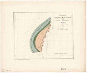
Lageplan, Grundstücksgrenze, Grenzsteine mit Distanzen, Grundstück unterteilt in durchnumerierte Parzellen. "Die Oder" und Straße von Speyer nach Ketsch eingezeichnet.
- Reference number
-
Abt. Generallandesarchiv Karlsruhe, H Hockenheim 26
- Dimensions
-
31 x 71 (Höhe x Breite)
- Notes
-
Pause
- Further information
-
Orientierung: NW
Originalmaßstab: 1:2 000
- Context
-
Gemarkungspläne >> Badische Orte >> H >> Hockenheim, Stadt, HD
- Holding
-
Landesarchiv Baden-Württemberg, Abt. Generallandesarchiv Karlsruhe, H Gemarkungspläne
- Creator
-
Autor/Fotograf: Kulturtechn. Büro, Karlsruhe
- Date of creation
-
1934
- Other object pages
- View digital item at providers-website
- Rights
-
Es gelten die Nutzungsbedingungen des Landesarchivs Baden-Württemberg.
- Last update
- 04.04.2025, 8:02 AM CEST
Data provider
This object is provided by:
Landesarchiv Baden-Württemberg. If you have any questions about the object, please contact the data provider.
Landesarchiv Baden-Württemberg. If you have any questions about the object, please contact the data provider.
Object type
- Karten und Pläne
Associated
- Autor/Fotograf: Kulturtechn. Büro, Karlsruhe
Time of origin
- 1934
Other Objects (12)

Speierer Grün Abteilung 1

Gemarkung Altlußheim - Speierer Grün (Rückseite)
Speyerer Grün (zwischen Rhein, Altlußheim und Hockenheim HD)
Speierer
Postamt Hockenheim
Postamt Hockenheim
Postamt Hockenheim
Postamt Hockenheim
Postamt Hockenheim
Postamt Hockenheim
Postamt Hockenheim
Postamt Hockenheim
Speierer Grün Abteilung 1
Gemarkung Altlußheim - Speierer Grün (Rückseite)
Speyerer Grün (zwischen Rhein, Altlußheim und Hockenheim HD)
Speierer
Postamt Hockenheim
Postamt Hockenheim
Postamt Hockenheim
Postamt Hockenheim
Postamt Hockenheim
Postamt Hockenheim
Postamt Hockenheim
Postamt Hockenheim
Speierer Grün Abteilung 1
Gemarkung Altlußheim - Speierer Grün (Rückseite)
Speyerer Grün (zwischen Rhein, Altlußheim und Hockenheim HD)
Speierer
Postamt Hockenheim
Postamt Hockenheim
Postamt Hockenheim
Postamt Hockenheim
Postamt Hockenheim
Postamt Hockenheim
Postamt Hockenheim