- Alternative title
-
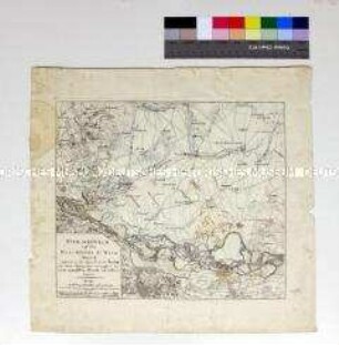
PLAN DU COMBAT NAVAL DE LA GRENADE LE & JUILLET 1779 / GAGNÉ PAR MR. LE CTE. D'ESTAING SUR L'AMIRAL BYRON
- Location
-
Deutsches Historisches Museum, Berlin
- Inventory number
-
Do 2006/776
- Measurements
-
Höhe x Breite: 36,7 x 62 cm (Blatt)
Höhe x Breite: 35,5 x 57,7 cm (Karte)
- Material/Technique
-
Papier, Kupferstich, teilkoloriert
- Classification
-
Kartografie (Gattung)
- Subject (what)
-
Grenada
Kleine Antillen
Mittelamerika
- Event
-
Herstellung
- (who)
-
Verlag: Esnauts et Rapilly
- (where)
-
Paris, Frankreich
- (when)
-
um 1779
- Rights
-
Deutsches Historisches Museum
- Last update
-
24.03.2023, 9:30 AM CET
Data provider
This object is provided by:
Stiftung Deutsches Historisches Museum. If you have any questions about the object, please contact the data provider.
Stiftung Deutsches Historisches Museum. If you have any questions about the object, please contact the data provider.
Object type
- Schlachtenkarte
Associated
- Verlag: Esnauts et Rapilly
Time of origin
- um 1779
Other Objects (12)

Combat de Reichenberg
Combat de Turckheim
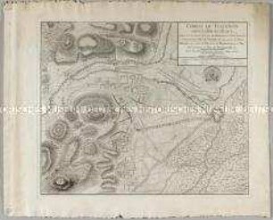
Combat de Lowositz, en Bohéme, gagné par le Roi de Prusse sur l'Armée Impériale aux ordres du Feldmaréchal de Brown, le 1er Octobre, 1756.
Combat de REICHENBERG, en Bohéme, Gagné par le Prince de Bevern, Lieutenant-Général commandant un Corps de Troupes Prussiennes, sur un autre des Impériaux, conduit par le Feldzeugmeister Comte de Koenigsegg, le 21. Avril, 1757.
Combat de ROSSBACH, en Saxe, gagné par le Roi de Prusse sur l'Armée Françoise, aux ordres du Prince de Soubise, et sur celle de l'Empire, commandée par le Prince de Saxe-Hildburghausen, le 5. Novembre, 1757.
Combat de MOYS, dans la Haute Lusace, gagné par les Troupes Impériales, aux ordres du Duc d'Aremberg et du Général de Nadasti, sur un Corps détaché des Prussiens, commandé par le Lieutenant Général de Winterfeld, le 7. Septembre, 1757.
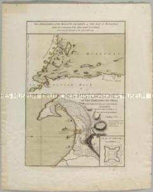
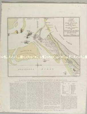
The operations of his Majesty's Squadron in the bay of Honduras / The attack and escalade on the 20th of October 1779 of San Fernando de Omoa. Mit einer Nebenkarte: Plan of the Fort

Plan de la Bataille d'Abukir
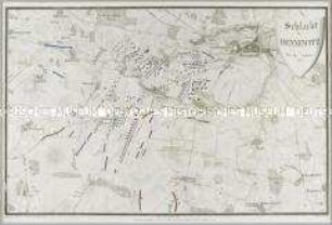
Schlacht bei Dennewitz den 6ten September 1813
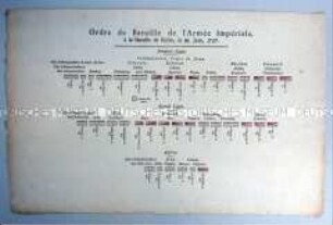
Ordre de Bataille de l'Armée Impériale, à la Bataille de Kolin, le 18. Juin, 1757.
Karte zur Schlacht von Groß Aspern auf dem Marchfeld bei Wien 1809
A Plan of the Attack, of Fort Sulivan
Combat de Reichenberg
Combat de Turckheim
Combat de Lowositz, en Bohéme, gagné par le Roi de Prusse sur l'Armée Impériale aux ordres du Feldmaréchal de Brown, le 1er Octobre, 1756.
Combat de REICHENBERG, en Bohéme, Gagné par le Prince de Bevern, Lieutenant-Général commandant un Corps de Troupes Prussiennes, sur un autre des Impériaux, conduit par le Feldzeugmeister Comte de Koenigsegg, le 21. Avril, 1757.
Combat de ROSSBACH, en Saxe, gagné par le Roi de Prusse sur l'Armée Françoise, aux ordres du Prince de Soubise, et sur celle de l'Empire, commandée par le Prince de Saxe-Hildburghausen, le 5. Novembre, 1757.
Combat de MOYS, dans la Haute Lusace, gagné par les Troupes Impériales, aux ordres du Duc d'Aremberg et du Général de Nadasti, sur un Corps détaché des Prussiens, commandé par le Lieutenant Général de Winterfeld, le 7. Septembre, 1757.
The operations of his Majesty's Squadron in the bay of Honduras / The attack and escalade on the 20th of October 1779 of San Fernando de Omoa. Mit einer Nebenkarte: Plan of the Fort
Plan de la Bataille d'Abukir
Schlacht bei Dennewitz den 6ten September 1813
Ordre de Bataille de l'Armée Impériale, à la Bataille de Kolin, le 18. Juin, 1757.
Karte zur Schlacht von Groß Aspern auf dem Marchfeld bei Wien 1809