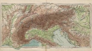
Karte
Atlas der Alpenländer : Schweiz, Savoyen, Piemont, Tirol, Salzburg, Erzhth. Oesterreich, Steyermark, Illyrien, Ober-Italien, &c. ; IX. Blätter

- Alternative title
-
Karte Der Alpen
- Location
-
Forschungsbibliothek Gotha -- SPA lg2° 00297
- Extent
-
1 Bl., 1 Kt auf 9 Bl, Gesamtgr. 186 x 123 cm, je Teil 62 x 41 cm
- Language
-
Deutsch
- Notes
-
Maßstab in graph. Form (geographische Meilen, Kilometer). - Nullmeridian: Ferro. - Mit Bergstrichen Sammlung Perthes
- Contributor
- Published
-
Gotha : Justus Perthes , 1863
- URN
-
urn:nbn:de:urmel-7f535ce2-ad54-4805-8ae0-3285e2a7ba752-00011321-014
- PURL
- Last update
-
14.04.2025, 12:54 PM CEST
Data provider
This object is provided by:
Forschungsbibliothek Gotha der Universität Erfurt. If you have any questions about the object, please contact the data provider.
Forschungsbibliothek Gotha der Universität Erfurt. If you have any questions about the object, please contact the data provider.
Object type
- Karte
Associated
Time of origin
- Gotha : Justus Perthes , 1863
Other Objects (12)

Atlas der Alpenländer; Schweiz, Savoyen, Erzherzogtum: Österreich, Steyermark, Oberitalien

13: Umgebungen von Wolfsberg in Illyrien und Stainz in Steyermark

22: Umgebungen von Möttnig in Illyrien und Cilli in Steyermark
Oberitalien : Piemont, Lombardei, Venetien, Friaul, Emilia-Romagna
Oberitalien : Piemont, Lombardei, Venetien, Friaul, Emilia-Romagna

17: Umgebungen von Völkermarkt in Illyrien und Windisch-Gratz in Steyermark

27: Umgebungen von Rann in Steyermark und Landstrass in Illyrien, nebst der politischen Eintheilung des Herzogthum's Steyermark
Kunstdenkmäler im westlichen Oberitalien. Lombardei, Piemont, Ligurien, Aostatal
Oberitalien : Aosta, Friaul, Ligurien, Lombardei, Piemont, Südtirol, Trentino, Venetien

Karte Des Königreichs Illyrien Und Des Herzogthums Steyermark nebst dem Königlich Ungarischen Littorale

Reise durch Tyrol, Oberitalien und Piemont nach dem südlichen Spanien
Alpenländer
Atlas der Alpenländer; Schweiz, Savoyen, Erzherzogtum: Österreich, Steyermark, Oberitalien
13: Umgebungen von Wolfsberg in Illyrien und Stainz in Steyermark
22: Umgebungen von Möttnig in Illyrien und Cilli in Steyermark
Oberitalien : Piemont, Lombardei, Venetien, Friaul, Emilia-Romagna
Oberitalien : Piemont, Lombardei, Venetien, Friaul, Emilia-Romagna
17: Umgebungen von Völkermarkt in Illyrien und Windisch-Gratz in Steyermark
27: Umgebungen von Rann in Steyermark und Landstrass in Illyrien, nebst der politischen Eintheilung des Herzogthum's Steyermark
Kunstdenkmäler im westlichen Oberitalien. Lombardei, Piemont, Ligurien, Aostatal
Oberitalien : Aosta, Friaul, Ligurien, Lombardei, Piemont, Südtirol, Trentino, Venetien
Karte Des Königreichs Illyrien Und Des Herzogthums Steyermark nebst dem Königlich Ungarischen Littorale
Reise durch Tyrol, Oberitalien und Piemont nach dem südlichen Spanien