Monografie
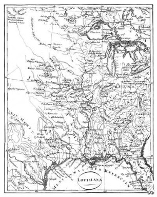
Map of Louisiana representing the several land districts : prepared to accompany the Surveyor General's annual report

- Alternative title
-
Map of Louisiana representing the several land districts
- Location
-
Württembergische Landesbibliothek Stuttgart -- 1Cg/911
- Extent
-
1 Kt.
- Language
-
Englisch
- Keyword
-
Landesaufnahme
- Contributor
-
McCulloh, J. (Assoziierter Name)
Bien, Julius (Assoziierter Name)
- Published
-
Donaldsonville, La. : Surveyor Generals Office , 1860
- URN
-
urn:nbn:de:bsz:24-digibib-kxp17362443965
- Last update
-
17.10.2025, 1:24 PM CEST
Data provider
This object is provided by:
Württembergische Landesbibliothek. If you have any questions about the object, please contact the data provider.
Württembergische Landesbibliothek. If you have any questions about the object, please contact the data provider.
Object type
- Monografie
Associated
- McCulloh, J. (Assoziierter Name)
- Bien, Julius (Assoziierter Name)
Time of origin
- Donaldsonville, La. : Surveyor Generals Office , 1860
Other Objects (12)

Prepared to Accompany the End of Life during Pandemics in Nursing Homes
Louisiana’s Castration Law

Representing terrorism
Louisiana
Louisiana.
Louisiana
Louisiana!
Louisiana
Louisiana
Louisiana
Representing African sexualities
Representing the absent
Prepared to Accompany the End of Life during Pandemics in Nursing Homes
Louisiana’s Castration Law
Representing terrorism
Louisiana
Louisiana.
Louisiana
Louisiana!
Louisiana
Louisiana
Louisiana
Representing African sexualities
Representing the absent
Prepared to Accompany the End of Life during Pandemics in Nursing Homes
Louisiana’s Castration Law
Representing terrorism
Louisiana
Louisiana.
Louisiana
Louisiana!
Louisiana
Louisiana
Louisiana
Representing African sexualities