Karte
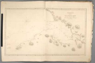
Ploskaja Karta južnoj časti berega Ostrova Vagi : Ot" mestečka Vajtiti do žemčužnoj <Reki
- Location
-
Leibniz-Institut für Länderkunde e.V., Leipzig
- Other number(s)
-
HK 1200 - 17 (Signatur)
- Material/Technique
-
unkolor.
- Inscription/Labeling
-
Aus: Atlas" k" Putešestviju Lejtenanta Kocebu Na Korablě Rjurikě V" Južnoe More I V" Beringov" Iroliv" / Otto von Kotzebue. - Titel unten rechts. - Maßstab in graph. Form (Verst" Rossijskich", Mil' Italianskich"). - Maßstab unten links. - Oben rechts: No. 18. - Relief in Schraffen. - In kyrill. Schrift
- Subject (what)
-
Altkarte
Straße
Bering-Straße
- Event
-
Veröffentlichung
- (where)
-
[St. Petersburg]
- (when)
-
1817
- Rights
-
Leibniz-Institut für Länderkunde e.V.
- Last update
- 15.05.2025, 12:43 PM CEST
Data provider
This object is provided by:
Leibniz-Institut für Länderkunde e. V.. If you have any questions about the object, please contact the data provider.
Leibniz-Institut für Länderkunde e. V.. If you have any questions about the object, please contact the data provider.
Object type
- Karte
Time of origin
- 1817
Other Objects (12)
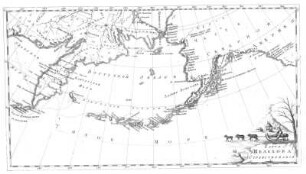
Merkatorskaja Karta Časti Sevěrnoj Ameriki : Načinaja ot" mysa Princa Valšskago do Zunda Kotcedu

Karta Tecenija Reki Irtyša ot" Omskoj Kreposti do Tobol'ska
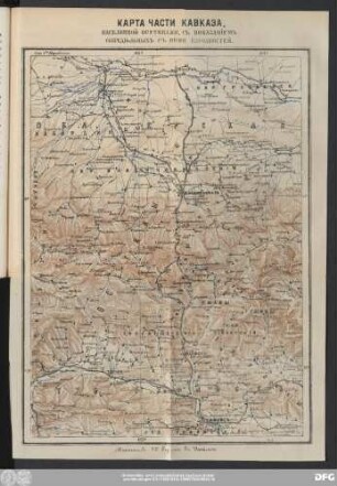
Карта Части Кавказа, Населенной Осетинами, Съ Показанieмъ Сопредiьльныхъ Съ Ними Народностей.

Ploskaja Karta W.noj Časti Ostr. Beringa : Iz" koej samogo SW.vago mysa Širota 55.° 17.° 18.° N.ja Dalgota W.vaja ot" Grinviča 194.° 6.° 37.°
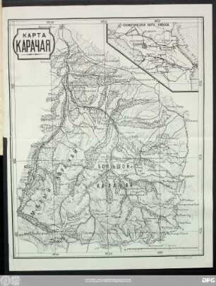
Карта Карачая.
Karta meriatorskaja
Karta Ekvatorskaja

Merkatorskaja Karta : Ot" široty 14° do 16° južnoj i dolgoty 137° do 149° Wj ot" grenviča s" označeniem" napravlenija tečenija i sklonenie kompasa
Karta Selechova Stranstvovanija
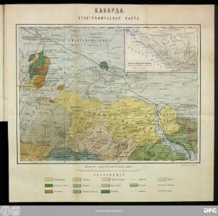
Кабарда. Этнографическая Карта.
Karta Predstavljajušcaja Kuban

Karta Rossijskoi Imperii
Merkatorskaja Karta Časti Sevěrnoj Ameriki : Načinaja ot" mysa Princa Valšskago do Zunda Kotcedu
Karta Tecenija Reki Irtyša ot" Omskoj Kreposti do Tobol'ska
Карта Части Кавказа, Населенной Осетинами, Съ Показанieмъ Сопредiьльныхъ Съ Ними Народностей.
Ploskaja Karta W.noj Časti Ostr. Beringa : Iz" koej samogo SW.vago mysa Širota 55.° 17.° 18.° N.ja Dalgota W.vaja ot" Grinviča 194.° 6.° 37.°
Карта Карачая.
Karta meriatorskaja
Karta Ekvatorskaja
Merkatorskaja Karta : Ot" široty 14° do 16° južnoj i dolgoty 137° do 149° Wj ot" grenviča s" označeniem" napravlenija tečenija i sklonenie kompasa
Karta Selechova Stranstvovanija
Кабарда. Этнографическая Карта.
Karta Predstavljajušcaja Kuban