Karte / Plan
Grundriss vom Asper Platz (Amt Schötmar),. mit Vermessungsangaben und Erläuterungen
- Reference number
-
D 73, 4/5491
- Dimensions
-
Höhe: ´42, Breite: 55, Maßstab: ca. 1:2.017
- Context
-
Allgemeine Kartensammlung (bisherige Kartei) >> 22. Tit. 4 (noch nicht klassifiziert) >> 22.11. Nr. 5401 - 5600
- Holding
-
D 73 Allgemeine Kartensammlung (bisherige Kartei)
- Date of creation
-
1787
- Other object pages
- Provenance
-
Behörden, Institutionen, Einzelpersonen (Sammlungen)
- Delivered via
- Last update
-
05.11.2025, 4:01 PM CET
Data provider
This object is provided by:
Landesarchiv Nordrhein-Westfalen. Abteilung Ostwestfalen-Lippe. If you have any questions about the object, please contact the data provider.
Landesarchiv Nordrhein-Westfalen. Abteilung Ostwestfalen-Lippe. If you have any questions about the object, please contact the data provider.
Object type
- Karten / Pläne
Time of origin
- 1787
Other Objects (12)

Karte des Uebbentruper Dornenbruchs, Breitenwegs, der Kreuzeichen, Krieger-, Asper-, Knetter- und Königsheide;. mit Vermessungsangaben und Erläuterungen
Teilungskarte vom Heideloh (Amt Schötmar),. Inselkarte mit Vermessungsangaben und Erläuterungen
Flurkarte von der Lehmgrube bei Schötmar,. Inselkarte mit Vermessungsangaben und Erläuterungen

Teilung des Asper Platzes zu Aspe
Flurkarte von der Sudheide (Amt Schötmar),. Inselkarte mit Vermessungsangaben

Aspers - Avista
Bauerschaft Werl-Aspe: Teilung des Asper Platzes
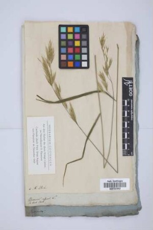
Bromus asper L.
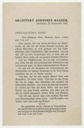
Opisthacanthus Asper! Stellingen

Henricus VI. Asper

NGA cASPER
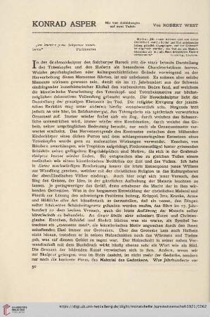
14: Konrad Asper
Karte des Uebbentruper Dornenbruchs, Breitenwegs, der Kreuzeichen, Krieger-, Asper-, Knetter- und Königsheide;. mit Vermessungsangaben und Erläuterungen
Teilungskarte vom Heideloh (Amt Schötmar),. Inselkarte mit Vermessungsangaben und Erläuterungen
Flurkarte von der Lehmgrube bei Schötmar,. Inselkarte mit Vermessungsangaben und Erläuterungen
Teilung des Asper Platzes zu Aspe
Flurkarte von der Sudheide (Amt Schötmar),. Inselkarte mit Vermessungsangaben
Aspers - Avista
Bauerschaft Werl-Aspe: Teilung des Asper Platzes
Bromus asper L.
Opisthacanthus Asper! Stellingen
Henricus VI. Asper
NGA cASPER